

How the streets of Mamaroneck got their names
And how subdivisions were developed
By Paul D. Rheingold, Rye NY
INTRODUCTION
This is a study of how the streets (about 210) in Mamaroneck got their names. But it is equally a study of the development of subdivisions of the land in Mamaroneck, which is largely how the area was developed. And as a result, it is a kind of history of the village/town.
My study follows a similar study on Rye, “The Streets of Rye—How They Got Their Names” (Rye Historical Society 2022). I also have done a similar but much more abbreviated, unpublished study of Port Chester.
This Mamaroneck study is also available as a book: Mamaroneck: How the Streets Got Their Names. How to buy it.
I have divided the Mamaroneck study into three regions, for which there is a geographic basis:
Part One: Rye Neck and Shore Acres—all of the development north of the Mamaroneck River and the harbor, up to the Rye City and Harrison lines.
Part Two: Orienta—all of the area south of the Post Road and west of the harbor
Part Three: Mamaroneck Ave. and section south and west of the Mamaroneck River.
Tap to go to the section:
• Introduction (con’t): Origin of street names, sources, illustrations
• Rye Neck
• Shore Acres
• Orienta
• Mamaroneck Avenue area
• Grand Park: Colossal vision that failed
• Washingtonville
• Southwest of Fenimore - Heathcote Hill
• Harbor Heights
• Video: How Mamaroneck streets got their names
• Hold old is your street and more to explore
How the streets came to be: Subdivisions
My study of the street name origins in Rye and Port Chester revealed that most streets came into existence as a result of subdivisions of lands. That is true of Mamaroneck as well. There were about 37 large subdivisions through which new streets were created. This process began in Mamaroneck in 1851, with Rye Neck Villages and Washingtonville.
Maps of all subdivisions were filed in the office of the Westchester County Clerk in White Plains, and all have been scanned and are available for examination. I have examined each Mamaroneck subdivision. The county’s maps are numbered, either from “1” on, or, if smaller, they were placed in a book, so that a citation would read, for example, “13-26”, meaning that the map is in volume 13, p. 26.
The clue to finding each subdivision and its map number is the consultation of the three Mamaroneck maps by G. M. Hopkins Co., done in 1929. Although the three main areas used in organizing this study are roughly equal in size, the number of subdivisions differ: Rye Neck/Shore Acres—10; Orienta—8; and Downtown and down toward Larchmont—19. This last section is the most complex relating to subdivisions and therefore street names.
Having the information on a subdivision may help to determine where the street names—and subdivision name—came from. This includes prior owners, the new owners, or developers.
Of course, there are some streets that came into existence separate from a subdivision. These tend to be older and more major streets, the Boston Post Road being the prime example.
Virtually all of the subdivisions logically follow topographical dividers. These are the Mamaroneck and Sheldrake rivers; the railroad; the Boston Post Rd.; and I-95. These main dividers have been used to create sub-sections of this study
Origin of street names
The origin of the names of streets is the major focus of this study. I have been able to determine some but far from all of the sources. In earlier subdivisions, Mamaroneck family names appear. Later, it is more of a commercial rush to come up with names.
The largest category of street names are the surnames of persons. However, there was seemingly a habit in Mamaroneck to use first names—of wives, children or the like. Mamaroneck, more than Rye or Port Chester, went in for first names. This was especially true in Rye Neck. There are approximately 82 streets with surnames and 24 with apparent first names.
The source of surnames is often famous residents, major landowners, or wealthy individuals, some of whom once lived in the area of the street. A handful of streets are named after U.S. presidents. A few are named for politicians. But many others have arcane names, no doubt related to the developer of a subdivision.
The next largest type of names can be placed in the category of geographical names, including names of places and physical descriptions: about 44 in Mamaroneck. Then comes what I could call “nature” names: some 33, including about a dozen tree names. There also about a dozen “happy” or “real-estately” names, such as Mt. Pleasant, Grand, Colonial.
That leaves about 14 which don’t fit into any of the above categories. Five of these are numbers. Unlike Rye and Port Chester, there is a paucity of Indian names, except for Mamaroneck Ave.
A study like this is never really done, so any information on names will be most welcome. You can send information to paul.rheingold@gmail.com.
Sources of information
Beyond the maps themselves, there are two major sources of information drawn on in this study. The most important one is a history of Mamaroneck by a famous citizen-historian, Edward Floyd de Lancey, which appears as a chapter in Scharf, History of Westchester County, (1886), vol. 1, pp. 846-888. This de Lancey as well as others is mentioned throughout this study. {Cited de Lancey (Scharf)) A second historical source of information is Charles Beard’s famous book, on Rye “Chronicle of a Border Town: History of Rye“ (1871), especially as to Rye Neck, which was not a part of Mamaroneck until the incorporation of Mamaroneck Village in 1895, (Cited as Baird). Also of tremendous help is Google, including the Ancestry site.
This study is also greatly aided by Mamaroneck resident Michael Meaney, a retired Journal News/lohud.com editor. This help far exceeds editing and includes original research on former residents for whom streets are named. This has involved reading old newspapers online.
Illustrations
To make this study more readable, we have placed relevant images, of the person involved, the mansion that once stood on the property, views of streets, photos of street signs, and most importantly the subdivision maps as filed in White Plains. Some of these images are old postcards and some are from the Westchester Historical Society.
Rye Neck/Shore Acres—Section 1
Rye Neck
Rye Neck is the land north and east of the Mamaroneck River, running up to Rye. It was developed as part of the Town of Rye and only became part of Mamaroneck in 1895 with the incorporation of Mamaroneck Village. This includes the Shore Acres section.
PART ONE: NORTH OF BOSTON POST ROAD
Streets before Subdivisions
Subdividing of land began relatively early in the Rye Neck area, with the large Rye Neck Villages in 1851. This was farmland owned by two Rye Neck residents, George Barry and Noah B. Tompkins—discussed below.
However, before that there were streets in the area, meeting the needs of travel and commerce:
--Boston Post Rd-- 1600s (a/k/a Main St)—this linked plantation to plantation. In Rye Neck the Post Rd ran over a narrow crossing of the Mamaroneck River near where Tompkins Ave is today.

Boston Post Road bridge near Mamaroneck Avenue looking toward the village about 1895

Historic Distance Marker on East Boston Post Road indicating 23 miles from New York City. Benjamin Franklin supposedly measured the distances in 1753 with an odometer affixed to his carriage, though there is some doubt that the story is true. The marker stands in the small park at Tompkins Avenue and the Post Road.

Plaque with the 23-miles marker aprovides some basics about its origins and does not mention Benjamin Franklin.

The mile marker seen in a vintage postcard, presumably ty in its original location, which would be on he Post Road about where the F.E. Bellows School fields are now.

Tompkins Avenue sign in Mamaroneck. Noah B. Tompkins and George Barry owned farms here that were developed, and the streets carry their names.
--Tompkins Ave (was a stretch of Boston Post Rd in its old course). Noah B. Tompkins (1837-1891). Charles Washington Baird in his book Chronicle of a Border Town—History of Rye (1871) (cited hereafter as Baird) describes Tompkins’ role in the Civil War, as a member of The Union Defense Committee of the Town of Rye. The committee collected funds to relieve the families of volunteers who enlisted in the war effort, and later to pay bounties to substitutes for local men who were drafted. Tompkins also served on the Rye Neck Board of Education and on the Union Savings Bank board of trustees. He is buried in Greenwood Union Cemetery.

North Barry Avenue sign in Mamaroneck. George Barry and Noah B. Tompkins owned farms in the area that were developed.
--Barry Ave N & S. (was First St). George Barry—died 1866. George Barry is reported among the delegates to an October 1858 local Democratic convention for the Second Assembly District in Westchester held at the Westchester County Courthouse in White Plains. The delegates, from various towns, nominated Edmund D. Sutherland as the Democratic candidate for Assembly. They also elected eight delegates - not Barry - to a Democratic Congressional Convention that was to be held in Nyack in Rockland County. In the Assembly election, Sutherland lost by 306 votes to candidate James S. See the Eastern State Journal reported. See ran under a fusion party of Whigs and the temperance movement.

News article from the Oct. 8, 1858 Eastern State Journal of White Plains lists George Barry (bottom of the article) as one of the delegates to a Democratic convention for the Second Assembly District in Westchester. He is listed as a delegate from Rye - the Town of Rye, which includes Rye Neck. Mamaroneck Village was not incorporated until 1895.
---Rail Road St (now Halstead Ave)
--Union St–post Civil War patriotic name
--also West St—direction name, but street runs north here
Subdivision Streets
A: Before 1900
Map: Rye Neck Village subdivision plan, 1851
Click on title above or map itself for a larger version.

Rye Neck Village subdivision map from 1851. First Street became Barry Avenue, Old boston and Post Road became Tompkins Avenue. “Boston Turnpike” is the current Boston Post Road Railroad Avenue is now Halstead Avenue.
**Rye Neck Village 1851 [map 337, 381] on farms of Barry and Tompkins—320 lots. See map above.
--Union St—see above

Melbourne Avenue in a vintage photograph (Westchester County Historical Society)
--Melbourne Ave.(formerly Third St)--?
--DuBois--? (formerly Montheith Ln)
--Spruce St.–tree name
--Beach Ave (formerly Second St.)—not near a beach
--Orchard St—possibly an orchard here
--Hinman Pl--possibly named for Harry D. Hinman, b. 1819—in 1880 lived in Rye
--Pine St—tree name
--Walnut St—tree name
--Ward Ave--?
--Anita Ln—runs off Union, added later: first name

An advertisement for lots in Barry and Tompkins’ Rye Neck Village development
--Jefferson Ave—third president of the US
--Hillside Ave—accurate topographical name (formerly Bridge St. when there was a bridge over the tracks)
--Grade St—stub toward railroad (formerly ran across the track—at grade level)
--Meadow St—perhaps a meadow here; nature name
--Willow St—tree name
--Cedar St--tree name
--1st, 2d, 3d Sts--in row from the north—1st St is now Barry Ave Extension.
**Lorenzen, Frederick 1885 [map 258 ]--a street is named after him in Larchmont--(1849-1928) from New Rochelle
--Jensen Ave--on land of florist Thorwald Jensen (c. 1844-1911) in Rye Neck. He was born in Germany. In 1878 he built greenhouses and a store on East Post Road, see photo. He served as a Mamaroneck Village trustee and as town excise commissioner. He had owned land known as Keeler Place.

Jensen’s Florist greenhouses at East Boston Post Road and Harrison Avenue in the early 1900s. CVS and Wells Fargo are located there now.

Thorwald Jensen’s obituary in the Mamaroneck Paragraph Oc. 12, 1911
--Keeler Ave—perhaps a local landowner as with Jensen.
**Van Amringe 1887 [map 7-27] Theodore Van Amringe, a member of Mamaroneck Village’s first Board of Trustees. Mentioned in Baird 160. On the plaque in front of Mamaroneck Public Library his son is listed as having donated the land as a memorial to his father. See photo below. (no street)

Van Amringe Memorial in front of the Mamaroneck Public Library.
**Tompkins Estate 1894 [map 10-74] This was an extension of Rye Neck Villages
--Linden St--tree name
--Brook St—if was a brook, long gone—would have run into Mamaroneck River
Subdivision south of Boston Post Road on South Barry
**Hawthornes 1871 [map 72, p 39-1] (this is an auction map of 38 “villa-plots”) formerly estate of Lot Hadden (there was an earlier Mamaroneck resident Bartholamew Hadden)

The Hawthornes Subdivision map, 1871. It was proposed for what is now South Barry Avenue (then Unon Avenue) between Post Post Road and what is now Guion Creek (Stony Brook at that time)
--Stuart Ave –Stuart was a former owner of this land
--Sophia St—perhaps his wife
B: 1900-1910
**Halstead Manor 1906 [map 1667, 1696] Halstead Land & Development Co. developed Halstead Farm. Jacob Halstead (1860-1915), a lawyer, lived in Orienta. Son was Jacob Sterling Halstead (1901-77).
Note: Here we have the use of first names, a common practice in this area of Rye Neck, perhaps children or relatives of the Halsteads.
--Rose Ln
--Henry Ave
--Park Ave—reference to Florence Park (which was not built upon originally as it was a swamp—since drained and made into a park)
--Franklin Ave
--Ernest became Florence St
--English Pl—perhaps where family came from (on original map was also a French st)
--Edward Pl
--Fourth and Fifth Sts
--Carroll Ave

Dr, John F. Hunter was Mamaroneck village president - mayor - from 1911 until at least 1920. Could Hunter Street have been named for him? (Westchester County Historical Society Photograph)
Later --Hunter St and Barbara Ln-- runs off Hunter—developer’s wife’s name?
**Hains Park 1905 [maps 1528,1636] Mamaroneck Land & Improvement Co. Augustus Van Amringe Hains (1863-1940). He was elected mayor in 1929 and the Democrat had also served as justice of the peace, assessor and tax collector over 50 years in public life, according to a New York Times obituary. Some tie to Gedney family.
Note: [Map 1528 – Hains Section A—west of train tracks and over to river—names below, plus extended Jefferson. Map 1636—Section B--Wagner and Carroll from Boston Post Road to railroad]
Several streets use first names—a practice in this section of Rye Neck
--Lorraine St
--Harold St
--Louis St
--Bradley St
--Grove St---perhaps was a grove of trees here at one time
--Wood St—trees? –runs next to Grove.
Note: Also there was David M. Hains—his farm was in his estate 1909 [map 1846] Grove St cuts through it. North of train tracks.
**Highland Terrace 1907 [map 1734] Mamaroneck Land & Improvement Co. See map below.

The 1907 subdivision map for Highland Terrace including Carroll, Wagner, and Frank avenues and Lorena Street.. Railroad Avenue became Halstead Avenue.
Note: it appears that once again most of the streets here are first names of people, probably related to developer.
--Wagner Ave
--Frank Ave
--Lorena St
C. 1910-1930

Sterling Avenue Street sign in Rye Neck. John Sterling (1844-1918) was a partner in a New York City law firm and developed the Osborn Home in Rye.
**Sterling 1922 [map 2446] John Sterling (1844-1918)—also did development in Rye (Osborn Home); wealthy partner in NYC law firm; left a lot of money to Yale.
Note: all streets begin with S.
--Shelburne Ave—Sterling had his summer home in Shelburne, MA
--Sherman Ave—probably named after his partner Shearman
--Sterling Ave--John
--Stoneybrook Ave—runs along a very small brook to its south (which goes under the Boston Post Rd and is Guion Creek)
--Short St—accurate name
--Sunnyside Ave—real estate name
--Hornidge Rd—appears to be separate from Sterling but developed at same time. May have been an owner there with this surname –there was a William Hornidge in Mamaroneck
Also –Osborn Ave., off of Harrison Avenue—old family name
--River Rd—near Grove and Barry, runs to the Mamaroneck River.
Later streets in this region (mostly subdivisions of a single large lot)
--Ryewood Farms Rd—off of Harrison, near West—name link to Rye
--Tulip Tree Ln—off of Ryewood—perhaps a tree there; nature name
--Pine Knoll Ln—nature name. See Pine Knolls—1927 [map 3135]
--Hampshire Rd—off of Grove St—some relationship to golf course?
--Laura Joy Circle--names of granddaughters of developer
Shore Acres
PART TWO—SOUTH OF BOSTON POST ROAD, SHORE ACRES

Advertisement for Shore Acres properties in 1916
**Shore Acres—1928 [map 2064]--layout by Clifford B. Harmon & Co.—not the street names we have today. Oakhurst-on-Sound. Newspaper report, Jan. 31, 1891: 120 acres sold by Mitchell Farm—to Frederick Bonner.
--The Parkway—what it is
--Shore Acres Dr—development name

Metropolitcan Opera Soprano Frances Alda in the 1920s. Alda Road wa reported named for her. (Library of Congress collection)
--Alda Rd— Reportedly named in honor of the then-famous Metropolitan Opera soprano Frances Alda (1879-1952), who was said to have visited the area, perhaps at the Charles Osborn estate, now the Mamaroneck Beach & Yacht Club. Alda sang with the Met for 22 years, until announcing her departure in 1929 to focus on opera performances on the radio for NBC. Alda Road was created sometime between 1911 and 1929 - the height of her fame. Her home was in Great Neck, Long Island. She published a memoir, Men, Women and Tenors, in 1937, and it is still available in the Westchester Library System. It does not mention Mamaroneck.
--Oakhurst Rd--original name of development
--Soundview Dr—geographical
--Garden Rd. –nature name
--Creek Rd—Guion Creek
--later added Kassel Ct—name? (is a town in Germany)
**Harbor Lawn 1928 [map 3312]--formerly the Forhan estate
--Guion Dr-- early settler family in Mamaroneck and Rye; name of adjacent creek. The Guion Burial Ground overlooks the creek off of Stuart Ave. It contains at least 44 gravestones with burials from 1808 to 1908.

Guion Burial ground overlooking Guion Creek (Photo by Kathy Barney)
--Lawn Terrace—geographic
--Harbor Hill—geographic
Notes on other streets
Map: Union Avenue plan, 1870: Tap on the image to see a larger version

Plan for Union Avenue, bottom of the map, to run from South Barry Avenue in Shore Acres across Mamaroneck Harbor and Shootfly Island to Orienta, approved in 1870 by the legislature. The road and crossing did not happen.
Note re South Barry Ave: In the 1870s, a street to be called Union Avenue was planned to run from South Barry across a bridge over the mouth of the Mamaroneck River to Orienta, which indicates that this development was by legislature and taking of lands, 1870. Fortunately, the road did not happen. See Union Avenue plan, 1870, above.

Tahoma, the mansion at the foot of South Barry Avenue built for stock broker Charles Osborn, is seen in 1956. It is now part of the Mamaroneck Beach and Yacht Club. (WestchesTER County Historical Society)
At the foot of S. Barry Ave. lies the mansion built for Charles Osborn, a New York City stock broker, designed by McKim, Mead & White. It was known as Tahoma, illustrated above. The buildings are now owned by the Mamaroneck Beach and Yacht Club

Alexander Taylor Jr. (1848-1899), member of the New York Stock Exchange and a rye Neck resident. (History of Westchester County by J. Thomas Scharf, 1886)

Alexander Taylor (1821-1896), a member of the New York Stock Exchange who lived in Rye neck (History of Westchester County by J. Thomas Scharf, 1886)
--Taylors Ln-- Alexander Taylor (1821-1896) – banker, businessman, member of the New York Stock Exchange. Born in Scotland; the family moved to the United States the year following his birth. His country home, Linwood, stood on this lane, where he lived year-round starting in 1882.
His son Alexander Taylor, Jr. (1848-1899) was also a member of the New York Stock Exchange. He is mentioned in Baird (p.514) as living near the head of Horseneck Creek. DeLancey (in Scharf) says Taylor’s home, “Chrismere,” was on a knoll facing the Long Island Sound. Perhaps all the same place as his father. Alexander Jr. was active in Republican politics.
Note:: In the 1867 Beers map what appears to be Taylors Lane runs down to Mamaroneck harbor, over land then called Guion’s Neck. On Guion Creek is the Van Amringe’s Emery Mill, and on the water is A. Whitlock Steamboat Landing.
--Colonial Ct—olde name
--Shadow Ln--trees

Actress Ethel Barrymore in 1901 when she was about 22 years old (Library of Congress Collection)
--Barrymore Ln—famous Barrymore family of actors—Ethel Barrymore (1879-1959), shown above, had house on Taylors Lane near here. Barrymore Ln was created by 1961.
Section 2: Orienta
This covers what was called Delanceys Neck and later Orienta.
A. Before 1900
The 1868 Beers map called Orienta shows the following streets south of the Boston Post Road:
Mamaroneck Ave—now Orienta Ave.
Bleeker Ave—see below
Heathcoat (not actually developed)
Walton Ave—see below

Street sign at Rushmore and Orienta avenues in Orienta. A portion of Orienta was developed from the estate of Thomas L. Rushmore (1822-1904).
Delancey Ave—now Rushmore Ave
These were bounded on the north by the Boston Post Rd, which then ran where Old Post Rd is today.

Delancey home after it was moved from atop Heathcote Hill down to Boston Post Road at Fenmiore Road, where the building stands today.
The earliest owner on record in this area was Thomas J. De Lancey. Thomas married Ann Heathcote. The family owned this area until 1848.
Note: the family name is spelled many ways. For the street name and general reference, I am using Delancey; but for individuals, I’m using the way they spelled it. As noted in the introduction, much of the history of Mamaroneck is taken from the chapter by Edward de Lancey in Scharf’s history.
Thomas Legrand Rushmore, Orienta developer, Mamaroneck’s first mayor

Thomas Legrand Rushmore, first president - mayor - of Mamaroneck Village, elected to one-year terms in 1896 and 1897. (Photo reproduced in the Daily Times Nov. 16, 1920)
Then, as far as major shapers of Orienta, came Thomas Legrand Rushmore, who bought from Delancey. Thomas L. Rushmore (1822-1904), was the first president (mayor) of Mamaroneck after its 1895 incorporation, elected to one-year terms in 1896 and 1897. He had moved to Orienta in 1856 and is buried in Rye, according to a May 21, 1896, article in the Mamaroneck Paragraph newspaper. At one point he owned almost the entire Orienta peninsula as well as properties elsewhere in Westchester, according to a 1904 article in the Eastern State Journal of White Plains, below. After his death on April 13, 1904, all his real estate in Mamaroneck and Rye was auctioned on July 12, 1904—an advertisement, below, tells about how he developed Orienta.

Thomas L. Rushmore’s home in Orienta. Rushmore owned most of the Orienta peninsula at one time.
Thomas L. Rushmore obituary notice, 1904

Thomas L. Rushmore obituary from the White Plains Argus published April 19, 1904. (New York Historic Newspapers collection)

Eastern State Journal article on the development of Thomas L. Rushmore’s estate, published May 14, 1904. (NY Historic Newspapers Collection)

Advertisement for an auction of properties from Thomas L. Rushmore’s estate on Orienta in 1904.
In addition to the land he purchased from the DeLanceys, Rushmore also bought another large plot of land in Orienta, owned by Isaac Hall (see below); this was nearer the harbor. On it Rushmore built a summer hotel, according to deLancey (Scharf, p. 854).
Subdivisions:
Edge-Water subdivision map, 1854 (pdf version):
Edge-Water proposed subdivision map, 1854.
**Edge-Water 1854 [map 677] See map illustration above. This map shows abutters: Greacen, Hall, and Palmer, and was filed by Anthony J. Bleeker (1799-1884) of New York City, a leading real estate agent. (Edgewater was the name of the Flagler estate—see below.)

Bleeker avenue street sign in Orienta. The street was named after Anthony J. Bleeker, a real estate agent.
--Bleeker Ave—named after the auctioneer (the eastern end of this street had been called Union Ave., with a proposed road across the harbor to what is South Barry, which was called Union—see Rye Neck section of this study).
--Walton Ave— early family in Mamaroneck, perhaps specifically for William Walton.
Also, map shows Delancey Ave, which became Rushmore Ave; and also Heathcote, which was not developed (though part became Bloomdale Ave—see below).
**Delancey, Thomas—1858 [map 2-13]

James Fenimore Cooper (History of Westchester County by J. Thomas Scharf, 1886)
--Cooper Ave—James Fenimore Cooper, novelist. His mother was a Fenimore, and he married a Delancey.
**De Lancey Park 1893 [map 1059] on property of Thomas Rushmore
--Rushmore Ave (was The Esplanade)
**Rushmore Subdivision 1895 [map 11-10]
--Hall St—for Isaac Hall (1799-1877), major property owner in this area
Later: --Royal Place—off of Hall—probably just a real estate name
**Rushmore, Thomas 1897 [map 12-33] See illustrated map below.
Rushmore subdivision map, 1897 (pdf version):

Map of propose subdivision of the Thomas L. Rushmore property on Orienta, 1897.
--Claflin Ave—probably John Claflin (1850-1938) of Larchmont, wealthy New York City merchant
--Stiles Ave.—probably William H. Stiles (c. 1826-1904) of Mamaroneck. Stiles was a member of Halsted & Stiles, New York City cloth importing merchants, according to a Brooklyn Eagle obituary republished March 26, 1904, in the Eastern State Journal of White Plains, see below. Stiles lived at “Quaker Ridge, Mamaroneck,” from 1865-1897. He was a landowner in this area. He was an active official of the Methodist Episcopal Church in Mamaroneck and was among a group of prominent laymen who established a church newspaper called The Methodist in New York City that was published from 1866 to 1885. Others involved in that effort included fellow Mamaroneck residents Thomas L. Rushmore and George I. Seney.

William Stiles obituary, published from the Brooklyn Eagle March 26, 1904, in the Eastern State Journal, White Plains.
--Beach Ave, renamed: Fairway Ave—leads over toward golf course
--Sylvan Ln—probably nature name

George I. Seney (Pawtucket (RI) Trubne, April 8, 1893, with his obituary)
-Seney Ave— George I. Seney, a New York City banker and philanthropist, who had a home in Mamaroneck. Note: A daughter of Thomas Rushmore was Lily Seney Rushmore.
Other subdivisions filed, no streets created:
**Knapp, Jonathan 1877 [map 172]
**Grecean, John 1878 [map 271]
**Fishing Hammock 1884 [map 738]
**Tootie B. McGregor 1887 [map 7-26] (You can read about her online—famous after moving to Fort Myers, Fl. Her husband, Ambrose, was president of Standard Oil Co.)
B. After 1900
**Rushmore Shore 1911 [map 33-75]
--Rushmore Ave—see above
**Deepwater 1912 [map 36-1] developed by Treuper-Shaw Co.
--Oakwood Rd—nature name
--The Crescent—named for shape, kind of
--later: Port Dr—1952 [map 8392]—nautical name
**Orienta Shore Hills 1916 [map 168] Rushmore Realty Co. (no streets added)

Greacen Point Road sign in Orienta. John Greacen (1818-1886), a rubber manufacturer, was the source of ‘Orienta’ as the name of the section.
**Greacen Point 1927 [map 3230]- John Greacen (1818-1886). His ancestors were from Scotland, he was engaged in rubber manufacturing, and he owned considerable land in Rye. His residence, discussed below, seems to have been on what we now call Flagler Dr. Greacen owned the point and had his house on it, which he named Orient, as he could see the sun rise. Eventually he added an “a” to the name and in time Orienta became the name for the whole area.

Henry M. Flagler (Library of Congress collection)
De Lancey (Scharf, p. 860), states that the toe or peninsula of land that is now Flagler Dr had its ownership as follows: Isaac Hall (mentioned above) sold this land to Greacen, who erected a mansion on it. Greacen sold to Henry M. Flagler, the Standard Oil baron who developed Palm Beach, FL, the railroad to Key West, and much else in that state. He called it Edgewater Point. The same peninsula was named Satanstoe in the novel by that name by James Fenimore Cooper, and that name is still used today
--Greacen Pt Rd
--Green Meadow Ln (off of Orienta)—nature name
**Eagle Hommocks 1923 [map 3415]
--Eagles Knolls Rd—fancy name
Note: a hommock is a small round hill, a knoll; here sticking up sometimes as an “island” in a marsh.
--Fairway Lane—golf course name
**Orienta Gardens 1926 [map 3468] --no street
**Humphries 1925 [map 68-33]--no street
C. Other streets in Orienta. Most developed as a road on one property.
--Harbor Island Dr—natural name
--Harbor Rd—off Rushmore
-- Protano Rd—1959 {Map 12486] off of Orienta—developer’s name.
--Toni Ln—off of Sylvan—name of developer’s wife?
--Indian Cove—off Rushmore—figurative name
--Beach Point Club— in the club
--Cove Rd—geographical—goes down to Cove at Knollwood Country Club (also Cove Rd S and N)
--Club Way—runs toward Eagle Knolls Country Club
--Fairway Green—runs up to golf course
--Flagler Dr see above.
--Hommocks Rd—over hommocks
--Old Hommocks Rd
--Oak Ln—nature name
-=-
The following seem to be in the Orienta Pointe section
(done by whom when?—or in pieces)
Skibo Ln—may be named after Skibo Castle in Scotland’s Highlands, once owned by industrialist Andrew Carnegie and then by his daughter, Margaret, until 1981 and now a private club. 1950s development
9 Acres Ln—amount of land
Nautilus Cove –1952 {Map 7983]–nature name—developed in 1953 [map 8664]
Seahaven—pretty name—developed in 1953 [map 9432]
Seven Oaks- 1954 {map 8965]—trees

Constable Drive street sign in Orienta. The constable family lived in Orienta and was connected to the Arnold Constable department store.
Constable—family name in Orienta, connected to the name of Arnold Constable department store in New York City—Amy Henrietta Constable Weatherbee was a granddaughter of Aaron Arnold and daughter of James Mansell Constable, the pair who created Arnold Constable. From 1890-1945, Amy and her husband, Edwin Weatherbee, and family lived on a 26-acre estate they called Waytes Court on Orienta Avenue. Today, their 31-room three-story stone mansion is part of the campus of the Westchester Day School and Westchester Hebrew High School.

Wayte’s Court as pictured in a vintage post card. The mansion was once the home of the family of Amy Henrietta Constable Weatherbee, daughter of one partner in the Arnold Constable department store chain and granddaughter of the other. Today, the mansion is part of the campus of Westchester Day School and Westchester Hebrew High School..
Bayhead Dr—geography name
Pirates Cove—pretty name or perhaps has factual basis
Section 3: Mamaroneck Avenue area, Washingtonville, Fenimore, Harbor Heights
1. Mamaroneck Ave. area

The foot of Mamaroneck Avenue by Boston Post Road as pictured in a vintage post card sometime after 1898, when the trolley started running. Koch’s Pharmacy is is at left with William Brown’s Orienta Market to its right.
We can begin analysis with the 1867 Beers map showing the section which is above the Boston Post Road and west of Mamaroneck River. It shows the following streets, the totality of the development in this area.

WINFIELD AVENUE RUNS FROM MAMARONECK AVENUE UP AROUND WASHINGTONVILLE AND BACK TO MAMARONECK AVENUE NEAR BARRY AVENUE IN THIS 1910-11 ATLAS OF WESTCHESER COUNTY CREATED BY GEORGE AND WALTER BROMLEY. The Winfield Hotel is noted at right, near the intersection of Mamaroneck and then-Barry avenues at Winfield. WINFIELD LATER WAS REPLACED BY THE NEW ENGLAND THRUWAY, THOUGH A STRETCH REMAINS FARTHUR UP MAMARONECK AVENUE in Harbor Heights.. (WESTCHESTER COUNTY ARCHIVES)
Winfield, which is now Mamaroneck Ave. There was a Winfield Hotel on the upper avenue, demolished by the Thruway, which opened in 1958. See a 1956 photo of the hotel from the Westchester Historical Society online collection

Original Mamaroneck train station, center, at Depot Plaza off Mount PleasaNT Avenue, along with a hotel, left, in an undated vintage photograph. Note that the tracks are at street level. The station was built in 1848 and was replaced by the currentstation in 1888. (Westchester County Historical Society)
Mt. Pleasant Ave—happy name
Cross—now Elm St—tree name
High—now Prospect Ave—the view

Palmer Avenue Street sign. Many Palmers owned land in Mamaroneck.
Orchard—now Palmer Ave The progenitor of the large and wealthy Palmer family in this area was Samuel Palmer ( ). See de Lancey (Scharf, p. 858), who describes his large original holdings, eventually passed on to three sons.
Locust –gone?
Meadow—gone?
East of what is now Mamaroneck Ave
Mill—gone--Name relates to manufacturing
Race—gone—name relates to manufacturing—watercourse. The millrace ran down to a factory shown in the 1857 map. Doubleday & Dixon Hat company.
Franklin –gone?
Washington—now Spencer Pl
Railroad—now Halstead Ave—see part 1, Rye Neck.
Also added later: Phillips Park Rd—parking behind Mamaroneck Ave. Named for Arthur Phillips (1923-2006), mayor of Mamaroneck from 1965-77. The passage way was built around 1980.
And north of the tracks is Washingtonville—see below.
Of major importance to understanding the development of the downtown area, and an explanation for the subdivisions listed below which have factory names, is information taken from Scharf, The History of Westchester County (1886), p. 861. In 1811 the NY state legislature passed a special act incorporating The Westchester County Manufacturing Society, to purchase lands and goods to meet the objects of the law. Under this power, the Society in Mamaroneck bought two farms on the west side of Mamaroneck River and down to the harbor, owned by Gilbert Budd, totaling 244 acres.
The company constructed a dam on the Mamaroneck River, creating the Factory Pond, and built a factory. A succession of owners did not manage to make a go of it, however, according to Scharf. This caused a lot of legal confusion as to ownership of the land and led to a period of instability, but eventually leading to what follows
Downtown subdivisions
**Land of James C. Spencer—1885 [map 6-55,also 7-31; 1276 (1904) now is estate of Belle W. Spencer]
--Spencer Pl—name as above
--Valley Pl—topography
--Staub Ct—name of ?
Notes: Ward Ave—runs over from the east
**George Burger 1889--[map 8-111]— did not add streets
-=-
Grand Park: A monumental vision’s fatal ending
Now a little more history is needed to explain some of the following subdivisions. Andrew Wilson (1818-70) was for a while a major land developer in our area of Westchester. He developed two major projects in Rye. In Mamaroneck, he bought upward of 2,000 acres, running north and west from the Boston Post Road all the way up through what is Winged Foot Golf Course today. On this he planned a gigantic development, called Grand Park. This was even to include a world-class university. He got in over his head, went bankrupt and committed suicide. See New York Times obituary, Sept. 22, 1870.
More of the Wilson and Grand Park story is online in The Loop, Jan. 21, 2019. A map of the “Grand Central Subdivision of Grand Park” (undated—but map 65 of Westchester County) that shows the main portion of the whole project—which was never developed—is illustrated here. Note the plan for a hotel, university, and for a seminary. Also note that on the right it bordered “Sylvan Park” and on the north “Heathcote Manor” (which is in Scarsdale).The map states that Grand Park itself was on the property of T. N. Hawley, presumably a farm.
Part of the massive proposed Grand Park development prposed in the 1870s. It included a hotel, center; a seminary, upper left; and even a university, upper right center. The project was never built. White Plains Road, lower right, is Old White Plains Road.
With Wilson’s death went the gigantic project, but the following developments did occur:
**Grand Park –First Subdivision–1870 [map 459] 113 lots Andrew Wilson (also see map 65)
--Grand—became Fenimore Rd—as in James Fenimore Cooper (1789-1851) —his mother was a Fenimore (He married a Delancey).

What would have been Grand Park Avenue in the failed 1870s Grand Park development became Fenimore Road.

But Grand Park Avenue lives on for a two-block stretch when Fenimore Road crosses into Scarsdale.
--Rushmore (see section 2, Orienta) —became Maple St—tree name
--Livingston Ave—prominent NY family, some intermarriage with Richbell family (see below as to Richbell)
--Highland Dr—it is

Former Mamaroneck Town Hall, right, and kindergarten on Prospect Avenue in an undated photo. The Town Hall building is now the home of American Legion Post 90 and the kindergarten the home of the Seventh-Day Adventist Church. (Westchester County Historical Society photo)
--Prospect Ave—older street, see above
--Hoyt St—north side of railroad—Hoyt family early settlers in Mamaroneck
**Grand Park Addition to First Subdivision –1870 [map 467] (ordered by a trustee, one assumes of the Wilson estate) (see also map 460)
--Stanley Ave—possibly another family related to Delanceys/Heathcotes
--Bishop Ave-- possibly named for Bishop Heathcote DeLancey of Mamaroneck
--Palmer Ave—for Palmer family, see above
And this also involved development along Mt. Pleasant Ave. and Prospect Ave.
**Westchester Manufacturing Society 1878 [map 670, also 870]--132 lots

*Westchester Manufacturing Society proposed development map, tor Lower Mamaroneck Avenue, Mount Pleasant Aenue and what is now Prospect Avenue (Factory Street then). In this map, north is to the righ, Mamaroneck Avenue (‘The Road to White Plains’). runs across the lower par and Boston Post Road is at left. See the map below for the traditional orientation.

*Westchester Manufacturing Society proposed development map, tor Lower Mamaroneck Avenue, Mount Pleasant Aenue and what is now Prospect Avenue (Factory Street then). This map is in the traditional orientation, with north at the top. Boston Post Road runs across the bottom and Mamaroneck Avenue (The Road to White Plains) is at right and intersects with Mount Pleasant Avenue at top.
--Mt. Pleasant Ave—see name discussed above
--Factory St –became Prospect Ave—see above
(at the time this development ran across the Post Road where the water treatment plant is now)
**Factory Properties 1884 [map 6-46]—lots from Mamaroneck River to Mamaroneck Ave.
--High St. –appears gone now
Note: 0ther streets added later in the above area
--Johnson St (behind police station, court)—mayor?
--Library Ln—by public library; previously Elm St.
Around train station
Station Plaza—location name
Depot Plaza—runs south of train tracks

Court Bonny Brook Drum and Bugle Corps sometime before 1919. It may have been associated with a firehouse of the same name. (W.D. Daymon photo from Mamaroneck Historical Society archives)
Bonny Brook Park, 1891 [map 998] Alexander Taylor Jr., owner –he is son of Taylor of Taylors Ln—for Taylors see section 1, Rye Neck. Bonny Brook Park was the name for the current Columbus Park. At that time there was a firehouse there with the same name, and the Bonny Brook band pictured above may have been associated.
--Van Ranst Pl. --Dutch family name
--Sheldrake Pl—name of stream—taken from name of type of duck, but probably is a family name.
Note: map also has two undeveloped streets—Clatonia, Brookside.
**Lester Park 1891 [map 1069]
--Lester Ave—developer?
--Nostrand Ave—family name?—old Dutch name
--Howard Ave—family name?
--Hillside Ave-- runs over from the east and does run along the side of a hill
-=
**Underhill Park 1905 [map 19-80; also 23-3, 23-80]
--Underhill Ave—de Lancey (Scharf) discusses an early citizen John B. Underhill, a town supervisor in 1820 (p. 861)
--Grand Ave—Andrew Wilson’s development name--see above
Added: New St –new then, not now
also here: Monsignor Goodwine Ave –where St. Vito’s is—Monsignor John Goodwine, a pastor of St. Vito's Church who died in 1997.
**Mutual Life Insurance Co. 1931 [map 3219] (how insurance companies came to own various tracts of land in Mamaroneck is unknown)

Ralph and Elliot avenues street sign.
--Ralph Ave—this and others may be first names—related to developer?
--Elliot Ave
--Derman Ave— or surname?
--Gertrude Ave
**Locust Park 1931 {map 2965]
--Andrew St—first names—developer?
--Louise St
II.North of tracks: Washingtonville
Washingtonville 1851 [map 230] New York & Mamaroneck Homestead Assn.

Washingtonville subdivision proposal in an 1851 map. Many street names on this map have changed.
This is tied timewise with Rye Neck Villages as the earliest major subdivision. Many street names on the original map have changed. See illustration. Who were the people behind this? Project named for the first president of the United States.
--White Plains Rd—road to that city—pre-existed this subdivision
Streets running south (above tracks) to north
--Franklin—this is now Plaza Ave—a wide street
--Clay—Henry Clay, then secretary of state—now Waverly Ave—see below

Madison Street, one of several streets named for presidents along with Washington and Jefferson streets. .

Washington Street, which carries George Washington’s name.
--Jefferson—as street elsewhere with that name, now Madison St-- president
--Washington St--president
--Grand St—Andrew Wilson project—see above
--Warren—gone--Thruway cut through
--Union—same
Running on left side: Madison Ave.--this is now Plaza Ave—this street does not quite fit the definition of a plaza
Also Alling St—old Mamaroneck family name
Added: Pelham St—name of proposed Pelham-Port Chester Parkway replaced by Interstate 95.
**Waverly map 1870 [map 460, 467--also map 1095] (this is a subdivision of Grand Park, sold under the order of a trustee, one assumes of the Wilson estate). See maps.

Part of the proposed Grand Park subdivision in the Waverly map 460 from 1870. Note that the north arrow faces down, so street order is reversed.

Another section of the proposed Grand Park subdivision addition, map 467. Grand Park Avenue became Fenimore Road. In this map, north is up.
Map 1095 says developer is Rich & Downs, 1895. Map shows Grand Park Ave, which became Fenimore Rd—see above
--Fayette Ave--possibly named for American Revolutionary War General Lafayette, who visited Westchester in 1824.
--Waverly Ave—possibly for famous Sir Walter Scott novel, Waverley, published in 1814.
--Ogden Ave—early Mamaroneck settler family
--Rockland Ave—probably rocky area-
--Concord Ave—pretty name—peace—on original map was Waverly Terrace
--Center Ave—the center of this plan—this was not on the original map
--Northrup Ave.— may be old family name--not on original map
Also is Railroad Way—borders railroad and is location of spur tracks serving local businesses.
-=-
III. Southwest of Fenimore
**Heathcote Hill Tract—1900 [map 1366]--property of E. F. De Lancey; 1905 [map 1497]—amended map of Heathcote Realty Co. A major development with 13 sections along Prospect and Palmer. E.F. De Lancey wrote the chapter on Mamaroneck in Scharf (1886), and was the author of other historical books. He had a large estate in Orienta, where Beach Point Club is today. His book chapter has a multipage history of the de Lancey family.
Heathcote Hill was the site of the Revolutionary War battle on Oct. 21-22, 1776.
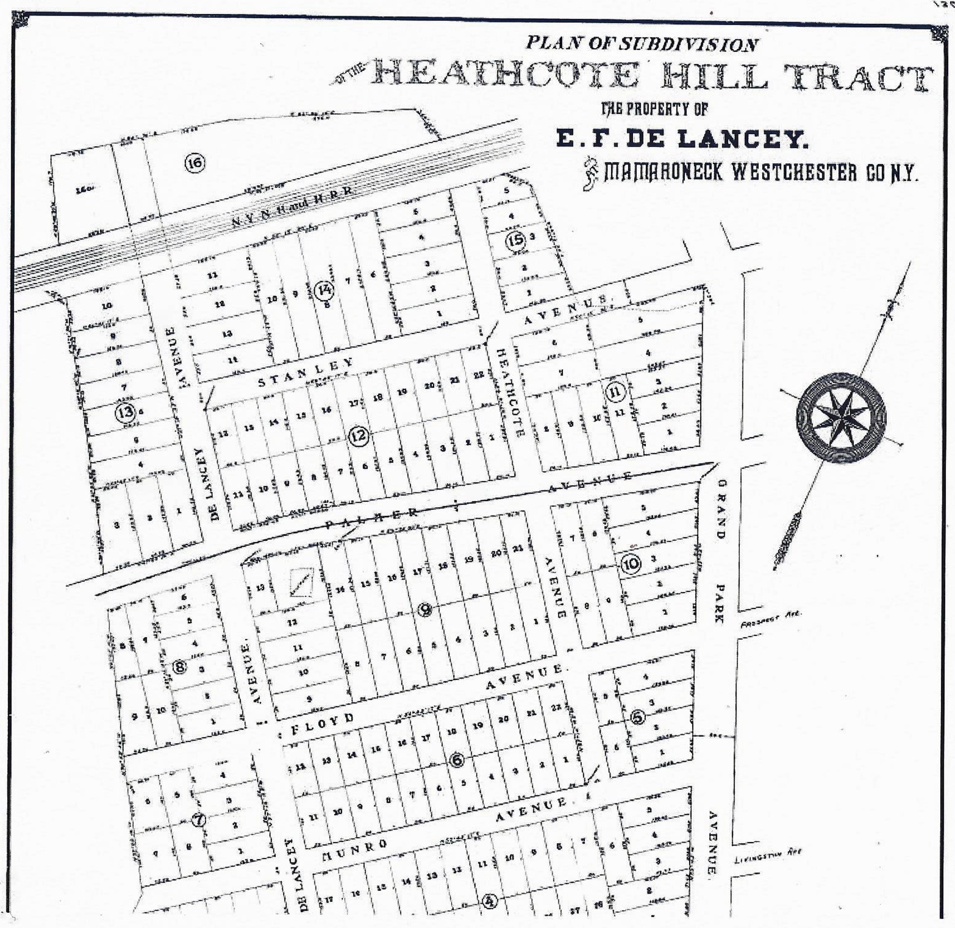
map shows part of the proposed Heathcote Hill Tract subdivision from 1900.
--De Lancey Ave—see above and introduction

Looking up Delancey Avenue to Heathcote Hill from West Boston Post Road in an undated vintage Post card
--Heathcote Ave—named for Caleb Heathcote (1665-1721) and his family. He owned large amounts of land in Mamaroneck, Scarsdale and in many other places. The land here was Heathcote Manor. He had a mansion on Heathcote Hill, located at what is now Fenimore Rd and Prospect Ave. He served as mayor of New York City. There were various intermarriages between this family and the Delanceys.
--Cortlandt Ave—family name connected by marriage to the Delancey and Heathcote families (also possibly shortening of Van Cortlandt)
--Munro Ave —named for Peter Jay Munro, nephew of John Jay who lived in Munro Manor House in Larchmont. His holdings on what was called Munro’s Neck are detailed in de Lancey (Scharf, p. 856).
--Palmer Ave—on this map as an extension; for Palmer see above
--Stanley Ave—extension of street, see above
--Floyd St—renamed Prospect Ave –extension of that street (Floyd family name of De Lancey)
--Sand St—in this area, family name or found sand there
(Note: On this map what is now Fenimore was then called Grand Park Ave.)
**Stanley Terrace—1908 [map 27-75]
This added more lots on the Heathcote Hill development. Development name from street name.
**M H & CA Davidson--1900 [map 13-64]. There is a Davidson family mentioned in Larchmont’s history.
--Woodbine Ave—nature name
--Florence—now Fulton Rd--perhaps after Robert Fulton (1765-1815), steamboat engineer and inventor.
--Carpenter Pl—family name in Mamaroneck
**Larchmont Gardens—1911 [map 1967]
Mostly in Larchmont but runs over into Mamaroneck
--Revere Rd—possibly Larchmont family name or named after Paul
--Harmon Dr—possibly related to the Harmon family mentioned in the Rye Neck-Shore Acres section.
--Hill St—same or topographical name as is a hill here
*Also: Richbell Rd—a tip of it runs over from Larchmont. Named after John Richbell (1616-1662), a wealthy Long Island merchant who bought what is now Mamaroneck and Larchmont in 1661 from the Siwanoy Indians. See also discussion of Heathcote family, above.
IV. North of Thruway: Harbor Heights
**Harbor Heights— 1906 [first map 13-67, map 1482—2d map 1905, 3d map 1906] Warranty Realty Co., a Manhattan company, Samuel Cohen, president.
Most or all seem to be surnames and may not be Mamaroneck names but related to developer

Travers Avenue street sign
--Travers Ave
--Warren Ave
--James St
--Girard St
--Nelson St
--Bryant CK
--Arlington St
--Lawrence Ave
--Grant Terrace—president?
--Soundview Ave -what developer wanted you to see
--Knickerbocker Ave—name for Dutch settlors—NYC real estate agent
--Bridge St—over the river
**Riverdale Park 1891 [map 814]—property of James L. Reynolds, Mt. Vernon. (by the side of Mamaroneck River)

Villa Avenue at Urban Street sign
--Villa Ave—type of big houses to be built
--Urban St—city-ish
--Chestnut Ave--tree name
--James St—last name of ?
--Ellis Pl—possibly related to developer
--Clairborne Rd—same
**Mamaroneck Knolls 1927 [map 3117, 3152 Knollwood](in this region had been a large farm and mansion called Knollwood)
--Raleigh Rd--first name
--Teresa Ln--?
--Drury Dr—perhaps named after famous London street?
--Crown Ct --not a topographical name
--Beechwood Dr—nature name
Note: later map adds:
--Birch Hill Ln—nature name
--Langdon Ln—possibly developer family name
--Knollwood Ave—from development name
--Sunset Rd—geographic name
Also Saxon Ct----from Saxon Woods park, which got its name from William Saxon, who had a saw mill on the upper Mamaroneck River.
-=-
Beyond Interstate 95 off of Old White Plains Rd
--Rockridge Rd—geographical name
--Highview St. —same
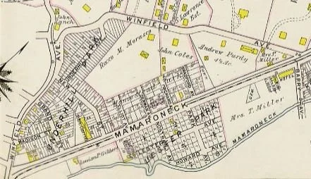
WINFIELD AVENUE RUNS FROM MAMARONECK AVENUE UP AROUND WASHINGTONVILLE AND BACK TO MAMARONECK AVENUE NEAR BARRY AVENUE IN THIS 1910-11 ATLAS OF WESTCHESER COUNTY CREATED BY GEORGE AND WALTER BROMLEY. The Winfield Hotel is noted at right, near the intersection of Mamaroneck and then-Barry avenues at Winfield. WINFIELD LATER WAS REPLACED BY THE NEW ENGLAND THRUWAY, THOUGH A STRETCH REMAINS FARTHUR UP MAMARONECK AVENUE in Harbor Heights.. (WESTCHESTER COUNTY ARCHIVES)
--Winfield Ave.-- possibly landowner (this had been the previous name of Mamaroneck Ave). The Winfield Hotel was on Mamaroneck Ave north of what is now North Barry Ave Extension, but it was demolished to make way for the New England Thruway, which opened in 1958. See a 1956 photo of the hotel from the Westchester Historical Society online collection.
--Baldwin Pl—perhaps a Larchmont family name
Video: How Mamaroneck Streets Got Their Names
Hear about the history, people, and strategies behind the names of Mamaroneck Village's streets in the video below. The presentation by society researcher Michael Meaney was recorded April 16, 2024. It's based on research by him and Paul Rheingold. (Video by Dorothee Maver)
Key points in the video (the numbers are time stamps):
Part 1
2: 38: Earliest roads connected Mamaroneck with the greater world.
Part 2
7:40: Streets reflecting Mamaroneck history, prominent families like the Heathcotes and Delanceys, and their roles in the Revolutionary and Civil wars.
17:05: Novelist James Fenimore Cooper marries Susan Augusta Delancey, lives for a time in Mamaroneck.
25:15: Streets named for the Founding Fathers.
Part 3
26:20: Mamaroneck's transformation from farms and estates to a suburb c. 1880-1920s.
28:00: How transformation happened: subdivisions.
28:30: Orienta attracts Gilded Age business titans seeking shorefront homes as escape from New York City bustle. They leave their mark on Orienta’s street names.
38:50: Rye Neck sees more farm-to-suburb transformation
40:25: Barry and Tompkins avenues named for George Barry and Noah Tompkins. Who they were.
42:00: Real estate names: 3 strategies in naming subdivision streets. Then, people behind more Rye Neck street names, including Guion, Jensen.
45:55: John Sterling and the streets with 'S' names in Rye Neck.
49:30: Shore Acres and the people and stars behind Taylors Lane, Alda Road, and Barrymore Lane.