
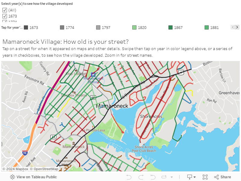
Mamaroneck Village: How old is your street?
Mamaroneck Village developed first along the Boston Post Road then outward from around the train station, largely between the 1860s and the 1920s.
The interactive map below as well as a photo gallery, charts and lists show the growth by selected periods along with information on every street.
Most streets go back a century or more. Half the village’s approximately 250 streets existed by 1910 and three-quarters by 1930. The village’s population saw its largest jump in the 1920s when many streets were added, followed by the ‘baby boom’ in the 1950s.
Tap on these links to go straight to a section:
• Gallery: How Mamaroneck Village developed showing when the streets appeared over selected years.
• Charts: Tracing Mamaroneck's development, which compare creation of streets and the growth of the population.
• List: Mamaroneck Village streets by year showing what streets existed by selected years.
• List: Every street's age, info gives when each street appears approximately, and further details for some. Plus: the story of the Boston Post Road.
• Video: How Mamaroneck streets got their names, the history, people, and strategies behind the names of Mamaroneck Village's streets.
• In-depth: How Mamaroneck streets got their names, a separate page with stories on the people and subdivisions behind the street signs.
• Where info came from: View vintage maps has links to some of the old maps used in compiling the information.
• Additions, suggestions, questions? How to contact us.
Interactive map: Find your street’s age
Gallery: How Mamaroneck Village developed
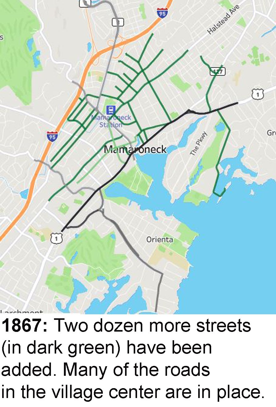
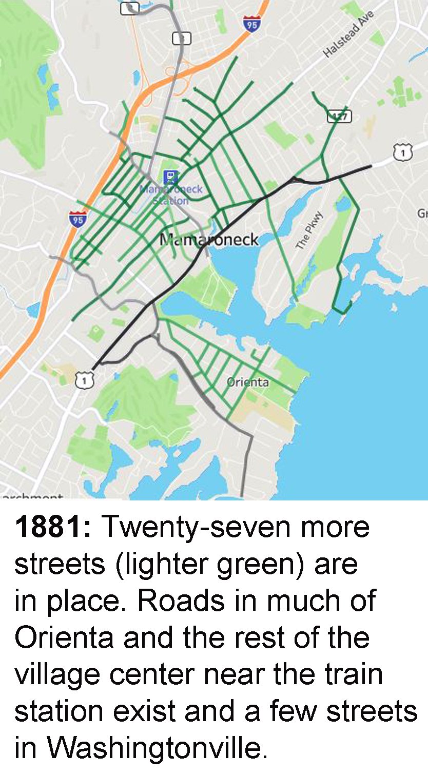
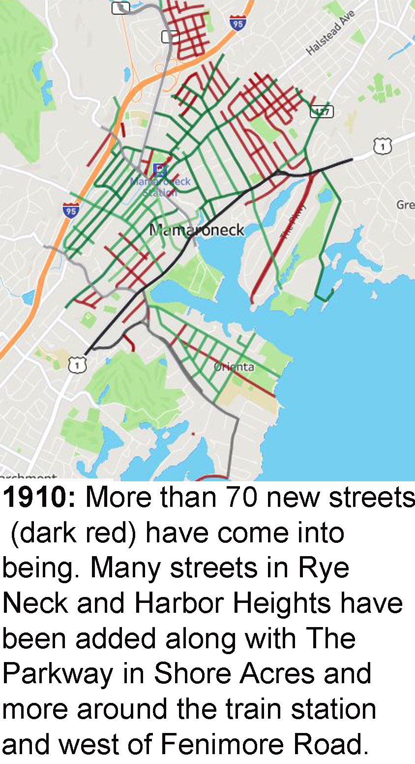
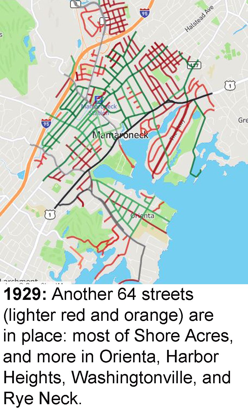
Scroll through the gallery to see what streets existed by selected years.
Charts: Tracing Mamaroneck’s development
When Mamaroneck Village's streets appeared
How total streets grew in Mamaroneck Village
How Mamaroneck Village's population grew
List: Mamaroneck Village streets by year
Streets that had appeared by selected years.
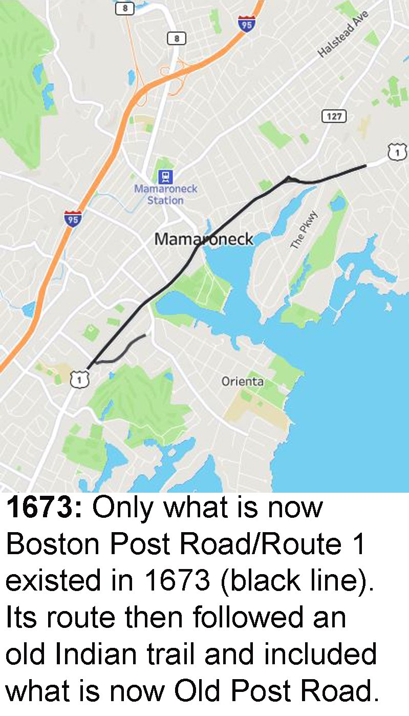
1673
Boston Post Road/Old Post Road
1774
Orienta Ave
1797
Mamaroneck Ave
Old White Plains Rd
Rockland Ave
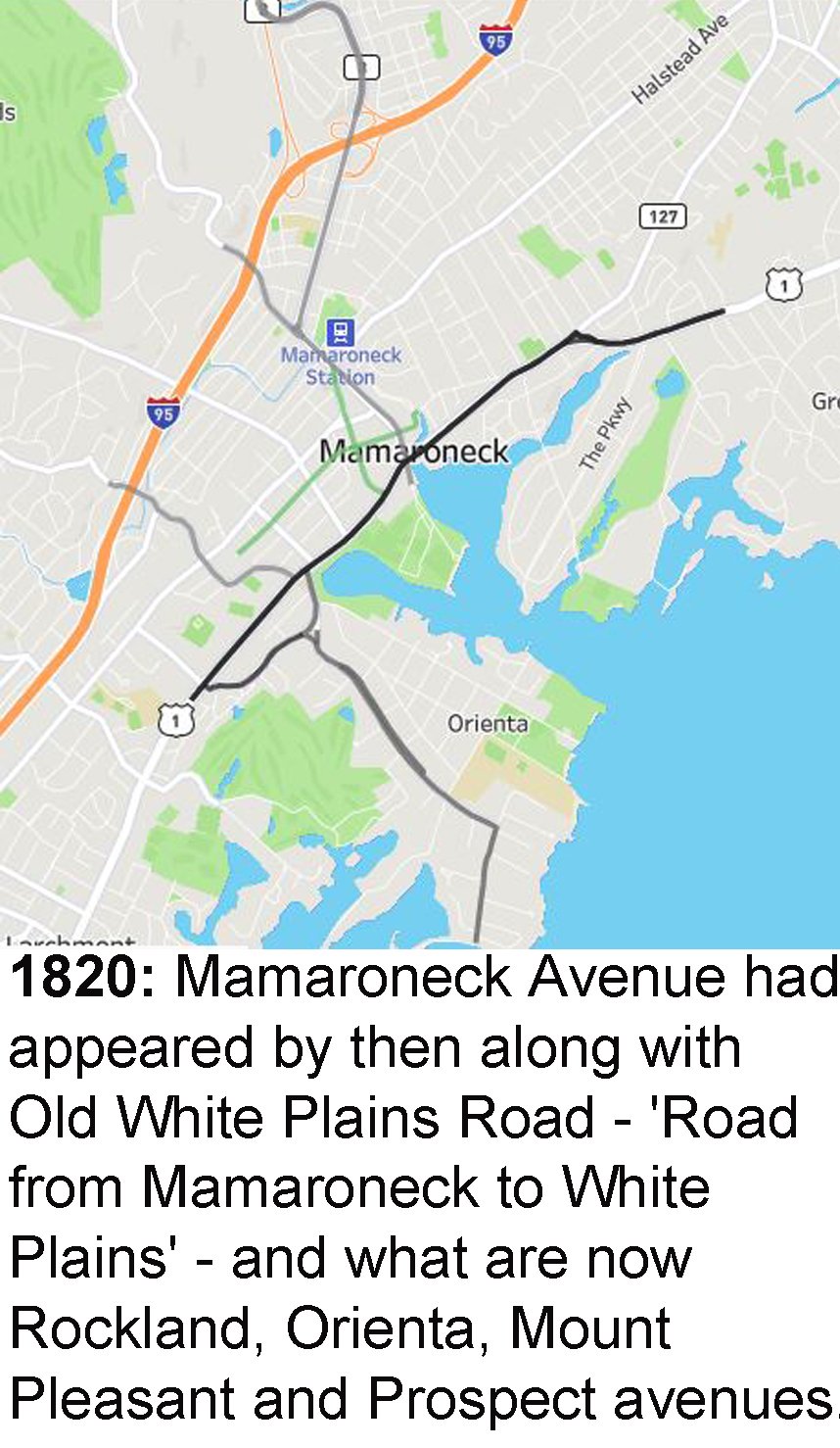
1820
E Prospect Ave
Mount Pleasant Ave
Prospect Ave
1867
Alling St
Cedar St
Center Ave
Dubois Ave
Grand St
Grove St
Halstead Ave
Harrison Ave
Hillside Ave
Jefferson Ave
Jefferson St
Library Ln
Meadow St
N Barry Ave
Palmer Ave
Plaza Ave
Spruce St
State Hwy 127
Taylors Ln
Tompkins Ave
Union Ave
Ward Ave
Washington St
Waverly Ave
West St
Willow St
1881
Beach Ave
Bishop Ave
Bishop Pl
Bleeker Ave
Claflin Ave
Concord Ave
Fairway Ave
Fairway Pl
Fayette Ave
Fenimore Rd
Forest Ave
Grade St
Hoyt Ave
Keeler Ave
Madison St
Maple Ave
Melbourne Ave
Oakwood Rd
Ogden Ave
Pelham St
Rockridge Rd
Rushmore Ave
S Barry Ave
Seney Ave
Stanley Ave
Stiles Ave
Winfield Ave
1910
1st St
3rd St
4th St
5th St
Arlington St
Bradley St
Carpenter Pl
Carroll Ave
Chestnut Ave
Cooper Ave
Cortland Ave
Delancey Ave
Depot Plz
East Flagler Drive
Edward Pl
Ellis Pl
English Pl
Fifth St
First St
Flagler Dr
Florence St
Fourth St
Frank Ave
Franklin Ave
Fulton Rd
Girard St
Grant Ter
Hall St
Harold St
Heathcote Ave
Henry Ave
Highview St
Hunter St
James St
Jensen Ave
Knickerbocker Ave
Lawrence Ave
Lorena St
Lorraine St
Louis St
Munro Ave
N James St
N Wagner Ave
Nelson St
Old Post Ln
Park Ave
River St
Rose Ave
Rose Ln
Second St
Sheldrake Pl
Sophia St
Soundview Ave
Spencer Pl
Station Plz
Stuart Ave
Sylvan Ave
The Parkway
Third St
Travers Ave
Underhill Ave (later also Monsignor Goodwine Ave)
Urban St
Valley Pl
Van Ranst Pl
Villa Ave
W Flagler Dr
Wagner Ave
Walton Ave
Warren Ave
Wood St
Woodbine Ave
1923
Highland Dr
Hommocks Rd
Northrop Ave
Northrup Ave
1929
2nd St
Alda Rd
Andrew St
Arthur St
Beach Point Club
Bradford Ave
Brook St
Cove Island
Cove Rd
Cove Rd E
Cove Rd S
Cove Rd W
Creek Rd
Crown Ct
Derman Ave
Drury Dr
Eagle Knolls Rd
Elliot Ave
Fairway Ln
Gertrude Ave
Greacen Ln
Greacen Point Rd
Greenhaven Rd
Guion Dr
Harbor Hill Ln
Harbor Island Park
Harmon Dr
Hill St
Hinman Pl
Howard Ave
Knollwood Ave
Langdon Ln
Lawn Ter
Lester Ave
Linden St
Livingston Ave
Louise Ave
New St
Nostrand Ave
Oakhurst Rd
Orchard St
Pine St
Raleigh Rd
Ralph Ave
Revere Rd
Rock Ridge
Royal Pl
Sand St
Shadow Ln
Sherman Ave
Shore Acres Dr
Short St
Soundview Dr
Staub Ct
Sterling Ave
Stoneybrook Ave
Sunnyside Ave
Sunset Rd
The Crescent
Walnut St
Westend Pl
1941
Bloomdale Ave
Oak Ln
Osborn Ave
Shelburne Ave
1953
Anita Ln
Bay Head
Bayhead Dr
Constable Dr
Garden Rd
Green Meadow Ln
Hampshire Rd
Johnson St
Nautilus Ln
Old Hommocks Rd
Pine Knoll Ln
Port Dr
Richbell Rd
Shelbourne Ave
Shore Rd
Toni Ln
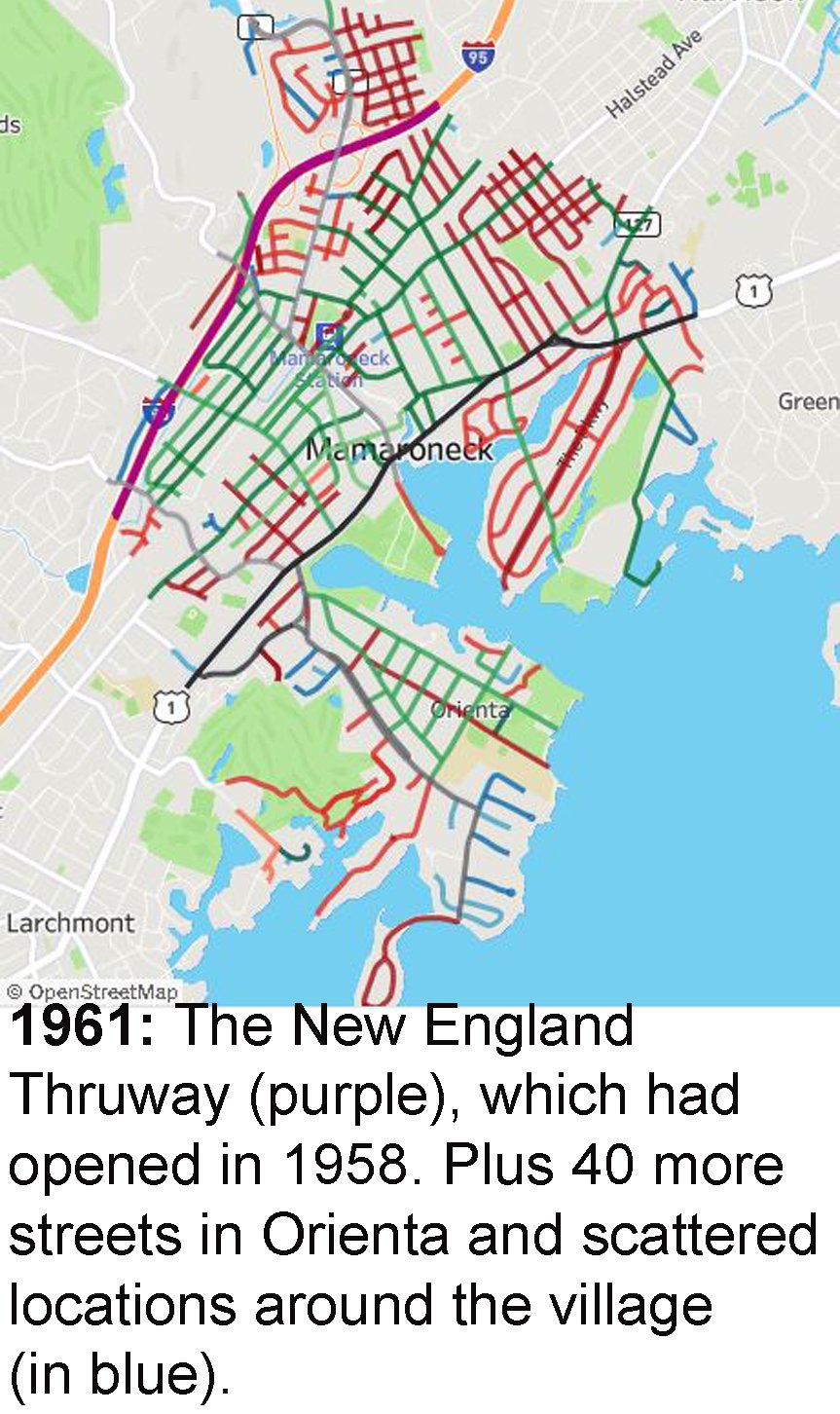
1958
I- 95/New England Thruway
1961
Baldwin Pl
Barrymore Ln
Beechwood Dr
Birch Hill Ln
Deerfield Ln
E Old White Plains Rd
Hampshire Rd
Hornidge Rd
N Barry Exd
Nine Acres Ln
Palmer Ct
Palmer Ter
Protano Ln
Saxon Dr
Seahaven Dr
Seven Oaks Ln
Skibo Ln
Standish Pl
Sylvan Ln
Teresa Ln
1970
Barbara Ln
Colonial Ct
Laura Joy Cir
Pirates Cove
Pirates Cove Ln
Railroad Way
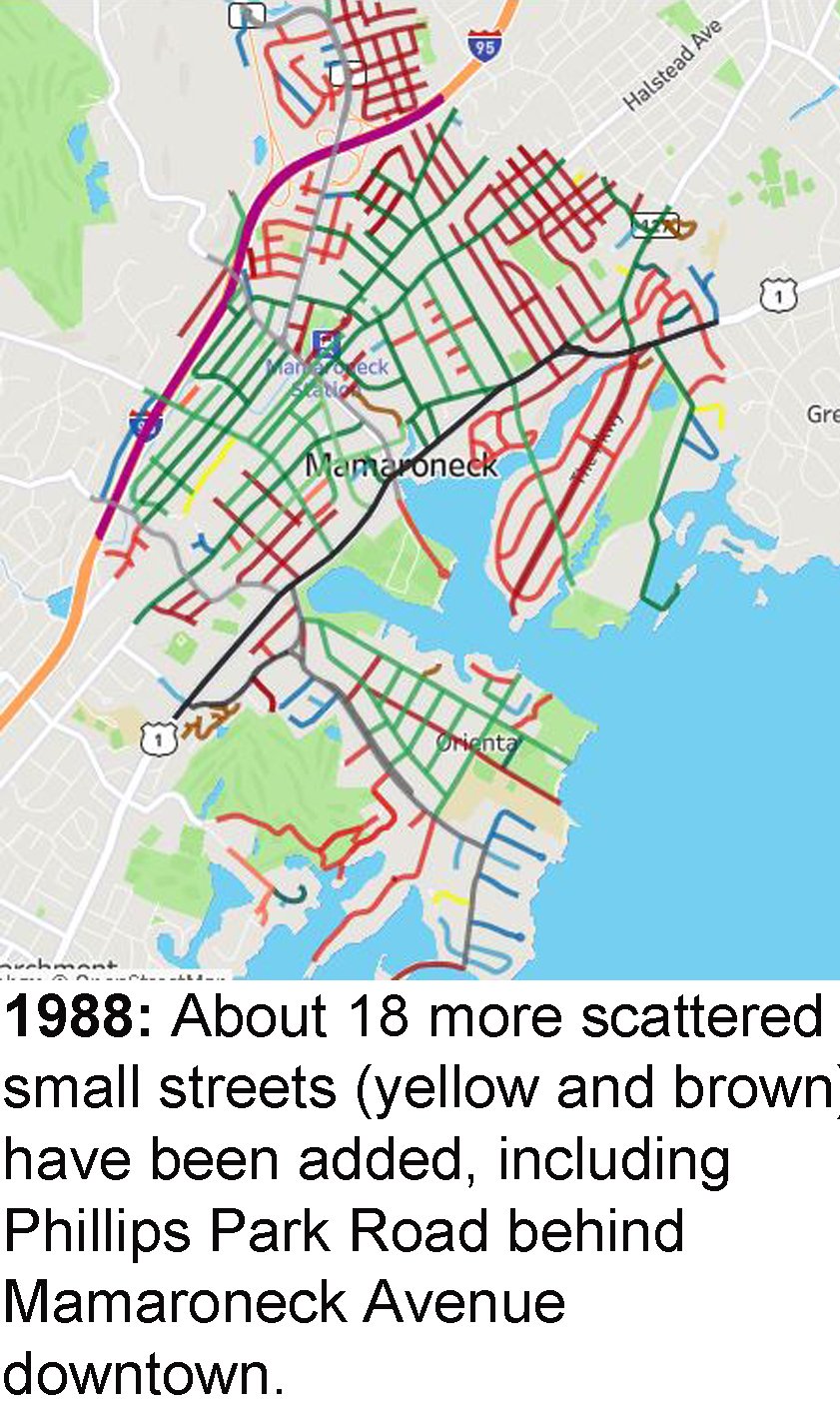
1988
Club Way
Fairway Green
Fairway Grn N
Indian Cove
Indian Cove Rd
Kassel Ct
Phillips Park Rd
Ryewood Farm Dr
Ryewood Farms
Top of the Ridge
Tulip Tree Ln
W Fairway Green
List: Every street’s age, info
Street name, when it appears approximately, and any further details. Tap on a letter to go to that part of the list.
1st St: Between 1882 and 1910.
2nd St: Between 1910 and 1929
3rd St: Between 1882 and 1910.
4th St: Between 1882 and 1910.
5th St: Between 1882 and 1910.
A

Benjanino Gigli and Frances Alda, who sang the opera “Martha” at the Metropolitcan Opera in December 1923. Alda Road reportedly was named in Alda’s honor. (Bain News Service photo in the Library of Congress collection)
Alda Rd: Between 1911 and 1929. Reportedly named in honor of the then-famous Metropolitan Opera soprano Frances Alda (1879-1952), who was said to have visited the area, perhaps at the Charles Osborn estate, now the Mamaroneck Beach & Yacht Club. Alda sang with the Met for 22 years, until announcing her departure in 1929 to focus on opera performances on the radio for NBC. She resided in Great Neck, Long Island.

Alling Street existed by 1867.
Alling St: By 1867. Alling Street is called Allino Street on 1867 map.
Andrew St: Between 1911 and 1929.
Anita Ln: Between 1941 and 1953
Arlington St: Between 1882 and 1910.
Arthur St: Between 1911 and 1929.
B
Baldwin Pl: Was originally a section of Grand Street but was cut off by the New England Thruway and first appears as Baldwin Place in the 1961 atlas.
Barbara Ln: Homes there date from around 1964.

Barrymore Lane street sign. Actress Ethel Barrymore lived in the area for half a century.
Barrymore Ln: Homes date from the early 1960s or so. Actress Ethel Barrymore of the famous Barrymore acting family lived nearby from about 1910 to 1959.
Bay Head: Called Shore View Drive in 1953 atlas, then Bay Head starting with 1961 atlas.
Bayhead Dr: Called Shore View Drive in 1953 atlas, then Bay Head starting with 1961 atlas.

Beach Avenue at Tompkins Avenue in rye Neck. Noah Tompkins’ and George Barry’s properties nearby became part of the Rye Neck Village subdivision.
Beach Ave: Between 1868 and 1881. Beach Avenue is called Second Avenue on the 1881 map and only ran a short block from Halstead (Railroad) Avenue on that map. It did not run its full current length.
Beechwood Dr: Homes date from 1961-63.
Birch Hill Ln: Most homes date from 1958-60
Bishop Ave: Between 1868 and 1881. The Mamaroneck train depot (New York New Haven and Hartford Railroad) was on the west side of Mamaroneck Avenue - the Bishop Avenue side - in the 1881 atlas, and there was a hotel at the depot as well as a freight depot.
Bishop Pl: Between 1868 and 1881.

Bleeker Avenue was earlier called Unon Avenue.
Bleeker Ave: Between 1868 and 1881. Bleeker Avenue (in Orienta) was Union Avenue on 1881 map.
Bloomdale Ave: Between 1930 and 1941
Boston Post Road: Indian trail to Turnpike to U.S. Route 1
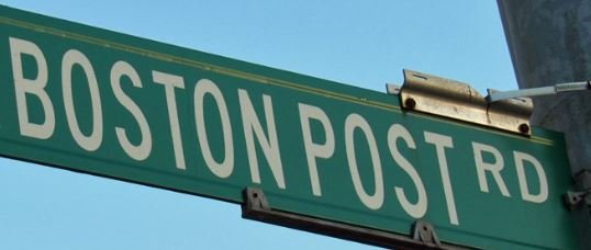
Boston Post Road street sign
Boston Post Rd: Boston Post Road existed by 1673 on the route of a former Indian trail. In 1661 when John Richbell purchased Mamaroneck, there was an Indian Trail referred to as the Secarah (in English, the Shore Path). This trail was referred to by colonists at that time as the Westchester Path. It didn’t cross the Mamaroneck River where Post Road does now. It wound up what is Mamaroneck Ave, down what is Prospect Avenue and then forded the river at the ledge of rocks where the sweet water falls into the salt.
By 1696 a bridge was built across the river at or about that point and at some point after that, Tompkins Avenue was the Westchester Path, which continued until it reconnected with the Boston Post Road, but the original Westchester path would have crossed about there (as opposed to the current crossing of the Post Road Bridge) even before there was a bridge.
This path was an Indian Trail, not much more than a foot path since the Indians in this area didn’t seem to use horses. By 1673 it would have been widened to at least accommodate a horse because it was the designated route for the postal rider. Governor Lovelace travelled to Hartford on this route later in 1673.
The road appears on a 1797 map as the Country Road and on an 1820 map as Turnpike and Old Boston Road. In 1800 the road had been expanded from two lanes to four and took its current route. Now called the Westchester Turnpike, it bypassed the Old Post Road and crossed the Mamaroneck on a new bridge continuing in Rye and bypassing Tompkins Ave.
East Boston Post Rd. was called Main St. in the downtown business district on 1867 map and Post Road past what is now Barry Avenue. Also called Main St. on 1881 map.
Bradford Ave: Between 1911 and 1929.
Bradley St: Between 1882 and 1910.
Brook St: Between 1911 and 1929.
C
Carpenter Pl: Between 1882 and 1910.
Carroll Ave: Between 1882 and 1910. The section is called Highland Terrace development or subdivision in 1910-11 and 1929-30 atlases.
Cedar St: By 1867
Center Ave: By 1867. Center Ave. was called Clay St. in 1881 and 1910 maps.
Chestnut Ave: Between 1882 and 1910. The section is called the Riverdale Park subdivision or development in 1910-11 and 1929-30 atlases.

Claflin Avenue, Orienta, Street sign.
Claflin Ave: Between 1868 and 1881. Claflin Avenue was Forest Avenue just off Boston Post Road on 1881 and 1910 maps. On 1929 map, Claflin was Forest off Rushmore then Claflin after the curve.
Club Way: Part of Fairway Green condominiums complex built in the mid-1980s
Colonial Ct: Most homes date to 1966-68.
Concord Ave: Between 1868 and 1881. Concord Ave. was Waverly Terrace on 1929 map. The street appears on 1881 atlas but no name is listed.

Constable Drive South Street sign recalls the Arnold Constable department store family’s estate.
Constable Dr: On the onetime Arnold Constable estate property. Called Stuart Court North and South in 1953 atlas and then Constable Drive North and South in the 1961 atlas.

Cooper Avenue Street sign
Cooper Ave: Between 1882 and 1910. In 1910-11 Westchester County Atlas, Cooper intersects with several streets that don't exist now: Pine, Cedar and Oak Street and a parallel street, Echo Street. They are shown south/west of Cooper where the Hampshire Country Club is now. They do not appear on the 1929 map and the area was part of the Hommocks Country Club.
Cortland Ave: Between 1882 and 1910. Spelled Cortland in the 1910-11 Westchester County atlas but Cortlandt in 1923 map and after, and that is the spelling today. Cortlandt Ave. east of Fenimore Road (1 block) was The Terrace on 1929 map.
Cove Island: Between 1911 and 1929.
Cove Rd: Between 1911 and 1929. Cove Road (Orienta) was Delancey Cove Road North and South on 1929 map.
Cove Road E: Between 1911 and 1929. Cove Road East appears in the 1929-31 Westchester County atlas as Delancey Cove Road East.
Cove Rd S: Between 1911 and 1929. Cove Road (Orienta) was Delancey Cove Road North and South on 1929 map.
Cove Rd W: Between 1911 and 1929. Cove Road (Orienta) was Delancey Cove Road North and South on 1929 map.
Creek Rd: Between 1911 and 1929.
Crown Ct: Between 1911 and 1929. The section is called Mamaroneck Knolls subdivision or development in the 1929-30 atlas.
D
Deerfield Ln: Homes date from 1956-66

Delancey Avenue street sign
Delancey Ave: Between 1882 and 1910.
Depot Plz: Called Union Street in 1910-11 atlas; Depot Pl. in 1929-30 and 1953 atlases; Station Plaza in 1941 1961 1970 1988 and 1998 atlases
Derman Ave: Between 1911 and 1929.
Drury Dr: Sometime before 1929. The section is called Mamaroneck Knolls subdivision or development in the 1929-30 atlas.
Dubois Ave: By 1867
E
E Boston Post Rd: Boston Post Road existed by 1673 on the route of a former Indian trail. The road appears on 1797 map as the Country Road and on an 1820 map as Turnpike and Old Boston Road. (The road was expanded from two lanes to four and took its current route and became a "Turnpike" around 1800.) East Boston Post Rd. was called Main St. in the downtown business district on 1867 map and Post Road past what is now Barry Avenue. Also called Main St. on 1881 map.
E Old White Plains Rd: By 1961
E Prospect Ave: By 1820. Was Factory Street on 1820 map and an unnamed factory and a separate dye building were located where the Regatta condo complex is today. On 1867 map, E. Prospect Avenue was High Street and the Doubleday and Dixon hat factory was located where the condo complex is today.
Eagle Knolls Rd: Between 1911 and 1929.
East Flagler Drive: Between 1881 and 1910. Flagler Drive appears in the 1910-11 Westchester County atlas as a private road
Edward Pl: Between 1882 and 1910.
Elliot Ave: Between 1911 and 1929.
Ellis Pl: Between 1882 and 1910. Listed as Elise Place on Westchester County Atlas 1910-11. (G.W. Bromley, publisher)
English Pl: Between 1882 and 1910. English Place was Fuller Place north of the train tracks on 1910 map.
Fairway Ave: Between 1868 and 1881. Fairway Ave. (Orienta) was Beach Ave. on 1881 map and was Beach Ave. and Beach Place (west of Claflin) on 1910 map.
F
Fairway Green: Part of Fairway Green condominiums complex built in the mid-1980s
Fairway Grn N: Part of Fairway Green condominiums complex built in the mid-1980s
Fairway Ln: Between 1911 and 1929.
Fairway Pl: Between 1868 and 1881. Fairway Place is called Beach in the 1881 Westchester County atlas.
Fayette Ave: Between 1868 and 1881. Fayette Avenue east of Fenimore Road was Jefferson St. on 1929 map.

Fenimore Road appears on maps by 1881. It would have been Grand Park Avenue in a massive development plan in the 1870s that failed.
Fenimore Rd: Between 1868 and 1881. Fenimore Road was Grand Park Avenue on 1881 map, but the monumental Grand Park development plan proposed in the 1870s failed. The plan would have developed 2,000 acres and included a hotel, a theological seminary, and a Grand Park University. Today, when Fenimore crosses north into Scarsdale, it is called Grand Park Avenue for a two-block stretch. In Mamaroneck, it was Fenimore by a 1910 map.
Read more about the Grand Park development plan and its fate in How Mamaroneck Streets Got Their Names elsewhere on the Mamaroneck Historical Society website.
Fifth St: Between 1882 and 1910.
First St: Between 1882 and 1910.

Flagler Drive recalls Henry M. Flagler, the Standard Oil baron who developed Palm Beach, Florida, and once lived here.
Flagler Dr: Between 1881 and 1910. Flagler Drive appears in the 1910-11 Westchester County atlas as a private road. Standard Oil baron Henry Morrison Flagler (1830-1913) once lived here. Flagler developed Palm Beach, Florida.
Florence St: Between 1882 and 1910. Florence St. was shorter than today on the 1910 map. It ran just one block north from Keeler Ave. There was a break around what was later Florence Park, then what was later Florence was Ernst Place south of the train tracks on 1910 map and was Dolan Place north of the tracks.
Forest Ave: Between 1868 and 1881.
Fourth St: Between 1882 and 1910.
Frank Ave: Between 1882 and 1910.
Franklin Ave: Between 1882 and 1910.
Fulton Rd: Between 1882 and 1910. Fulton Road was Florence Avenue on 1910 and 1929 maps.
G
Garden Rd: Between 1941 and 1953
Gertrude Ave: Between 1911 and 1929.
Girard St: Between 1882 and 1910.
Grade St: Between 1868 and 1881. Grade Street is called Grand Street on 1881 map.
Grand St: By 1867. On 1867, 1881 maps, Grand Street ran farther than today, from Rockdale (Rockland) Ave. to Old White Plains Road. Section between Old White Plains Road and Mamaroneck Avenue was labeled Underhill Park subdivision or development in 1910-11 and 1929-30 atlases.

Grant Terrace Street sign. It appeared by 1910.
Grant Ter: Between 1882 and 1910.
Greacen Ln: Labeled as a private road in 1929-31 atlas then as part of Greacen Point Road in 1941 and as Greacen Lane in 1953 atlas.
Greacen Point Rd: Between 1911 and 1929.
Green Meadow Ln: Houses date from 1948-50
Greenhaven Rd: Between 1911 and 1929.
Grove St: By 1867. The section is called Hains Park development in 1910-11 and 1929-30 atlases.
Guion Dr: Between 1911 and 1929.
H

Hall Street, Orienta, street sign.
Hall St: Between 1882 and 1910. Homes date back as far as 1902 with some others dating back to the 1920s. The area is referred to as the Rushmore subdivision in 1910-11 and 1929-31 atlases. In that 1929-31 atlas a small portion is labeled as the Orienta Hills subdivision.
Halstead Ave: By 1867. In 1867, Halstead Ave. only ran east of the Mamaroneck River. Halstead Ave. was Railroad Ave. west of Barry Ave. on 1881, 1910 maps.
Hampshire Rd: Between 1953 and 1961. The Hampshire Country Club was the Hommocks Country Club on 1929 map.
Hampshire Rd: Oldest home dates back to 1948.
Harbor Hill Ln: Called part of Lawn Terrace originally; labeled Harbor Hill starting with 1988 map.
Harbor Island Park: Playground, ballfields, etc., shown in 1929-31 atlas. Harbor Island is called Hog Island on an 1868 map. The name may have been a shortened version of Quahog, shellfish that inhabit mudflats.
Harmon Dr: Between 1911 and 1929.
Harold St: Between 1882 and 1910. The section is called Hains Park development in 1910-11 and 1929-30 atlases.
Harrison Ave: By 1867. T. Jensen Nursery stood where the CVS is now at Harrison Avenue and Boston Post Road, in 1910 Westchester County Atlas.

Heathcote Avenue appeared by 1910.
Heathcote Ave: Between 1882 and 1910.
Henry Ave: Between 1882 and 1910.
Highland Dr: By 1923. Houses there date back to 1905 and 1923.
Highview St: Between 1882 and 1910.
Hill St: Between 1911 and 1929.
Hillside Ave: By 1867. Hillside Ave. was Bridge St. on 1881 map and Hillside Lane (also Bridge St.) on 1929 map.
Hinman Pl: Between 1911 and 1929.
Hommocks Rd: Listed as 'Hommock Road' in 1911 atlas and 1923 map. A part leading from Boston Post Road was also called 'Causeway' in the 1911 and 1930 maps. In 1930, it ran past the Hommocks Country Club, now the Hampshire Country Club.
Hornidge Rd: Homes there date to the late 1950s.
Howard Ave: Between 1911 and 1929.
Hoyt Ave: Between 1868 and 1881. Hoyt Ave. was High Avenue on 1881 map.
Hunter St: Between 1882 and 1910. Hunter St. was Third St. on 1910 map
I
I- 95: Opened Oct. 15, 1958.
Indian Cove: Homes on this private road date from 1984-85.
Indian Cove Rd: Homes on this private road date from 1984-85.
J
James St: Between 1882 and 1910. The block of James Street off Chestnut Ave. was listed as Grove St. on 1910-11 Westchester County Atlas.
Jefferson Ave: By 1867. Jefferson Ave. was Jefferson St. on 1867 and 1881 maps.
Jefferson St: By 1867
Jensen Ave: Between 1882 and 1910. Thorwald Jensen (c. 1844-1911) owned land in the area and ran a florist business with greenhouses where the CVS and Wells Fargo on East Boston Post Road in Rye Neck are now.
Johnson St: Between 1941 and 1953.
K
Kassel Ct: Homes on this private road date from 1987.

Keeler and Jensen avenues in Rye Neck. Thorwald Jensen (c. 1844-1911) owned land in the area and ran a florist business with greenhouses where the CVS and Wells Fargo on East Boston Post Road are now.
Keeler Ave: Between 1868 and 1881.
Knickerbocker Ave: Between 1882 and 1910. The oldest homes date back to 1900.
Knollwood Ave: Between 1911 and 1929. The section is called Mamaroneck Knolls subdivision or development in the 1929-30 atlas.
L
Langdon Ln: Between 1911 and 1929. The section is called Mamaroneck Knolls subdivision or development in the 1929-30 atlas.
Laura Joy Cir: Homes date from 1963-65 or so.
Lawn Ter: Between 1911 and 1929.
Lawrence Ave: By 1910.
Lester Ave: Between 1911 and 1929.
Library Ln: By 1867. Library Lane was Cross St. on 1820, 1867 maps, Elm St. on 1910, 1929 maps.
Linden St: Between 1911 and 1929.
Livingston Ave: Between 1911 and 1929.
Lorena St: Between 1882 and 1910.
Lorraine St: Between 1882 and 1910. The section is called Hains Park development in 1910-11 and 1929-30 atlases.
Louis St: Between 1882 and 1910.
Louise Ave: Between 1911 and 1929.
M

Madison Street existed by 1881 and was originally called Jefferson Street.
Madison St: Between 1868 and 1881. Madison St. was called Jefferson St. in 1881 and 1910 maps. One block east of Old White Plains Road was Madison Street by 1910.
Mamaroneck Ave: By 1797 Appears as "Road from Mamaroneck to the White Plains" on 1797 map, as was Old White Plains Road, and unnamed on an 1820 map. At least one stretch of Mamaroneck Avenue was Winfield Avenue in 1867 but Mamaroneck Avenue by 1881.
Maple Ave: Between 1868 and 1881. Maple Ave. was Rushmore St. in 1881 map.
Meadow St: By 1867
Melbourne Ave: Circa 1870. Melbourne Ave. historic district dates to c. 1870. Melbourne was Third Ave. on 1881 map.
Monsignor Goodwine Ave: Named for Monsignor John Goodwine, a pastor of St. Vito's Church who died in 1997. Also called Underhill Avenue, which dates back to the late 1800s. Homes date to 1895, 1902, 1904, 1922, and 1927.
Mount Pleasant Ave: By 1867. Called Mount Pleasant Street on an 1820 map. A public school is shown on the 1867 and 1881 maps across from the cemetery and just down the street from the triangle intersection of Mount Pleasant and Mamaroneck Avenue. The railroad depot and a hotel were at that intersection at the time. The school is labeled School No. 1 on an 1868 map.
Munro Ave: Between 1882 and 1910.
N
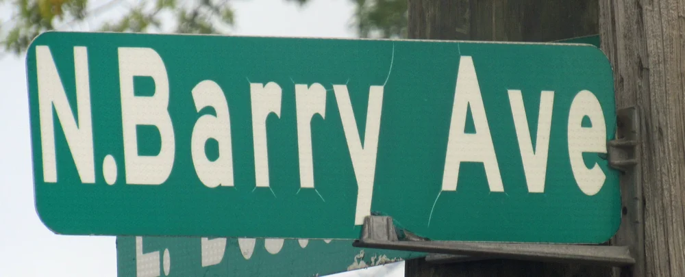
North Barry Avenue recalls George Barry, who had a farm there.
N Barry Ave: By 1867. A Mrs. Barry is shown as the owner of a home and property at what is now North Barry Avenue at East Boston Post Road, where the Sedona Taphouse is. An 1851 plan proposed a subdivision called Rye Neck Village on the farms of George Barry (died 1866) and Noah Tompkins (1837-1891) in this area. North Barry was called First Avenue then. It is called Barry Avenue by 1911.
N Barry Exd: Called North Barry Street in 1961 and 1970 atlases, the North Barry Avenue Extension in 1988 atlas. The Barry family owned a home and land as early as the 1860s at what is now North Barry Avenue and East Boston Post Road and later developed the area.
N James St: Between 1881 and 1910 North James Street was called Grove Street in the 1910-11 Bromley Atlas of Westchester County
N Wagner Ave: Between 1882 and 1910. The section is called Highland Terrace development or subdivision in 1910-11 and 1929-30 atlases.
Nautilus Ln: Homes there date from 1953.
Nelson St: Between 1881 and 1910.
New England Thruway: Opened Oct. 15 1958.
New St: Between 1911 and 1929.
Nine Acres Ln: Most homes date from 1956-61
Northrop Ave: Before 1923. Generally spelled as Northrup Avenue. One building dates from 1880, others from 1927, 1953 and 1957.
Northrup Ave: Before 1923. One building dates from 1880, others from 1927, 1953 and 1957.
Nostrand Ave: Between 1911 and 1929.
O
Oak Ln: On 1923 map as a unnamed extension of "Hommock" Road then as named road in 1929-31 atlas. Oldest home dates back to 1924.
Oakhurst Rd: Between 1911 and 1929. Oakhurst Road was White Road on 1929 map.
Oakwood Rd: Between 1868 and 1881.
Ogden Ave: Between 1868 and 1881.
Old Hommocks Rd: Between 1941 and 1953
Old Post Ln: Appears but is unnamed in 1910-11 atlas and a 1923 map, called just 'Lane' in 1929-30 atlas, and Post Lane in town property records. Listed as Old Post Lane in 1988 atlas.
Old Post Rd: By 1673. Was a stretch of the original Boston Post Road that existed by 1673 on the route of a former Indian trail. The road appears on 1797 map as the Country Road. Boston Post Road was expanded from two lanes to four and took its current route and became a "Turnpike" around 1800. So, Old Post Road appears separate from the Boston Post Road by an 1820 map, when it was called Old Boston Road.
Old White Plains Rd: By 1797 Appears as "Road from Mamaroneck to the White Plains" on 1797 map. A stretch through Washingtonville was called Winfield Avenue on 1881 and some later maps.
Orchard St: Between 1911 and 1929.

Orienta Avenue street sign
Orienta Ave: By 1774. Orienta Ave. appears as an unnamed stretch half its eventual full length from the Country Road - later Old Boston Post Road - on a 1774 map. It appears at full length in an 1867 map but is labeled Mamaroneck Avenue. It is called Union Avenue in an 1881 map. In a 1910-11 Westchester County atlas it is Union Avenue between Boston Post Road and Old Post Road and then is Orienta for the rest of its length.
Osborn Ave: Called Sterling Avenue in 1929-30 atlas, then Osborn Avenue in 1941 atlas.
P

Palmer Avenue existed by 1867.
Palmer Ave: By 1867. On 1867 map Palmer Avenue only ran for one block - from Mt. Pleasant Avenue to Mamaroneck Avenue (Winfield Avenue then) and was called Orchard Street. On 1881 atlas Palmer runs from Rockland Avenue to what is now Maple Avenue (was Rushmore Street then) and stops one block short of Mount Pleasant Avenue)
Palmer Ct: Serves the Palmer Terrace coooperatives built in 1961
Palmer Ter: Cooperatives built in 1961
Park Ave: Between 1882 and 1910.
The Parkway: Between 1881 and 1910. The Parkway was Oakhurst Avenue on 1910 map and Harmon Parkway on 1929 map.
Pelham St: Between 1867 and 1881. Pelham Street was part of Warren Street - a street as long as the parallel Grand Street on the 1929 atlas. Apparently cut short by Interstate 95. Unclear when it became called Pelham St.
Phillips Park Rd: Between 1970 and early 1980s.
Pine Knoll Ln: Between 1941 and 1953
Pine St: Between 1911 and 1929. Pine St. was Maple St. on 1929 map.
Pirates Cove: Most houses date to the mid- to late 1960s.
Pirates Cove Ln: Between 1961 and 1970
Plaza Ave: By 1867. Plaza Avenue was Madison Avenue on 1881 and 1910 maps.
Port Dr: Homes date from the mid-1950s.
Prospect Ave: By 1820. Was Factory Street on 1820 map. Prospect Avenue was High Street on 1867 map and only ran from Mount Pleasant Avenue to Mamaroneck Avenue (Winfield Avenue then). Prospect was High Street east of Fenimore Road on 1910 map.
Protano Ln: Homes date back to about 1961-64.
R
Railroad Way: Route of New Haven Line freight spur tracks from nearby businesses. Not named until 1988 atlas, but building with a Railroad Way address goes back to 1965.
Raleigh Rd: Home dates include 1927 to the 1950s to the early 1960s The section is called Mamaroneck Knolls subdivision or development in the 1929-31 atlas, but Raleigh Road ran for just one block off Knollwood Avenue at that time.

Ralph Avenue in Washingtonville exsited by 1929.
Ralph Ave: Between 1911 and 1929.
Revere Rd: Called Fulton (Willow) Road in 1929-31 atlas. Some homes date back to 1925.
Richbell Rd: Between 1941 and 1953
River St: Between 1882 and 1910.
Rock Ridge: Appears in 1929-31 atlas as a private road called Red Lion Lane and Outlook Place near the Red Lion Inn on Boston Post Road. Appears as Rock Ridge Road in 1941 atlas.
Rockland Ave: By 1797. Appears unnamed on 1797 map. Rockland Ave. was called Rockdale Ave. on 1881 map.
Rockridge Rd: Originally a stretch of Winfield Avenue, which dates back to at least 1881. Winfield was cut off by the New England Thruway and the part off Old White Plains Road became named Rockridge Road by an 1988 atlas but was Winfield earlier.
Rose Ave: Between 1882 and 1910.
Rose Ln: Between 1882 and 1910. Rose Lane was Rose Avenue on 1910 map.
Royal Pl: Called Hall Street in 1929-31 atlas. The area is referred to as the Rushmore subdivision in the 1929-31 atlas.

Rushmore Avenue, Orienta, street sign
Rushmore Ave: Between 1868 and 1881. Rushmore Avenue (Orienta) was Delancey Avenue on 1881 map but was Rushmore by 1910-11 map.
Ryewood Farm Dr: Ryewood Farms Condos appears in 1988 atlas, but the road does not appear until after 1998 atlas. The homes date from about 1986.
Ryewood Farms: Homes there date from the mid-1980s.
S
S Barry Ave: Between 1867 and 1881. South Barry Avenue was called Union Avenue on 1910 map. No name given on 1881 map although Barry Avenue is called First Avenue. The Barry family owned a home and land as early as the 1860s at what is now North Barry Avenue and East Boston Post Road and later developed the area.
Sand St: Between 1911 and 1929.
Saxon Dr: Homes date from 1955-62 or so
Seahaven Dr: Between 1953 and 1961 Most of the homes date from 1955-59.
Second St: Between 1882 and 1910.

Seney Avenue, Orienta, street sign
Seney Ave: Between 1868 and 1881. Seney Avenue south of Claflin Avenue was Richard Place on 1910 map and was Orchard Place west of Claflin on 1929 map.
Seven Oaks Ln: Most homes date to around 1956-57
Shadow Ln: Between 1911 and 1929.
Shelbourne Ave: Between 1941 and 1953
Shelburne Ave: Spelled Shelburne in the 1941 atlas but Shelbourne after that
Sheldrake Pl: Between 1882 and 1910. Shown as part of the Bonny Brook Park subdivision or development in 1910-11 and 1929-31 atlases. Section also labeled Depot Park in the 1929-31 atlas.
Sherman Ave: Between 1911 and 1929.
Shore Acres Dr: Between 1911 and 1929.
Shore Rd: Between 1941 and 1953
Short St: By 1930
Skibo Ln: Between 1953 and 1961
Sophia St: Between 1882 and 1910.
Soundview Ave: Between 1881 and 1910.
Soundview Dr: Between 1911 and 1929.
Spencer Pl: Between 1882 and 1910.
Spruce St: By 1867 Spruce St. was Sprague St. on 1881 map.
Standish Pl: The homes date to 1956 and 1961 but it is clearly labeled starting with the 1988 atlas
Stanley Ave: Between 1868 and 1881.
State Hwy 127: By 1867.
Station Plz: Called Union Street in 1910-11 atlas, Depot Pl. in 1929-30 and 1953 atlases, Station Plaza in 1941, 1961, 1970, 1988 and 1998 atlases
Staub Ct: Does not appear on maps before 2012 but homes date back to 1904 and 1922

Sterling Avenue street sign
Sterling Ave: Between 1911 and 1929.
Stiles Ave: Between 1868 and 1881.
Stoneybrook Ave: Between 1911 and 1929.
Stuart Ave: Between 1882 and 1910. The neighborhood is called Hawthorne Park in a 1910-11 atlas.
Sunnyside Ave: Between 1911 and 1929.
Sunset Rd: Between 1911 and 1929.
Sylvan Ave: Between 1882 and 1910. Sylvan Avenue was Meadow Avenue on 1910 map.
Sylvan Ln: Originally labeled as an extension of Sylvan Avenue but called Sylvan Lane in 1988 map.
T

Taylors Lane, Shore Acres, street sign.
Taylors Ln: By 1867. Alexander Taylor (1821-1896), banker, businessman, member of the New York Stock Exchange, lived in the area. His son Alexander Taylor Jr. (1848-1899) also was a member of the New York Stock Exchange and lived locally.
Teresa Ln: Homes date back to about 1958.
The Crescent: Between 1911 and 1929.
The Parkway: Between 1881 and 1910. The Parkway was Oakhurst Avenue on 1910 map and Harmon Parkway on 1929 map.
Third St: Between 1882 and 1910.

Tompkins Avenue recalls The Tompkins estate proposed for development as the Rye Neck Village subdivison by Noah Tompkins and George Barry along with Barry’s neighboring property..
Tompkins Ave: By 1867. An 1851 plan proposes a subdivision called Rye Neck Village for farms here owned by Noah Tompkins (1837-1900) and George Barry (died 1866). The street is already named Tompkins Avenue in an 1868 map. Part of the area is called the Tompkins estate in the 1910-11 atlas.
Toni Ln: Homes date from 1953-61.
Top of the Ridge: Condos built around 1984

Travers avenue in Harbor Heights probably dates from the early 1900s. Some houses date from 1902 and 1906. It appears on maps by 1910.
Travers Ave: Between 1881 and 1910. Some homes date from 1902, 1906, and 1908.
Tulip Tree Ln: Homes there date to the mid- to late 1980s.
U
Underhill Ave: Between 1882 and 1910. Also called Monsignor Goodwine Avenue, a tribute to Monsignor John Goodwine, a pastor of St. Vito's Church who died in 1997. Section was called Underhill Park subdivision or development on 1910-11 and 1929-31 atlases.
Union Ave: By 1867. Union Ave. was called Union St. in 1881 map.
Urban St: Between 1882 and 1910. The section is called the Riverdale Park subdivision or development in 1910-11 and 1929-31 atlases.
US Rte 1: By 1673 Boston Post Road existed by 1673 on the route of a former Indian trail. The road appears on 1797 map as the Country Road and on an 1820 map as Turnpike and Old Boston Road. (The road was expanded from two lanes to four and took its current route and became a "Turnpike" around 1800.) Boston Post Rd. was called Main St. in the downtown business district on 1867 map and Post Road past what is now Barry Avenue. Also called Main St. on 1881 map.
V
Valley Pl: Between 1882 and 1910. Valley Place was Washington Place on 1910, 1929 maps.
Van Ranst Pl: Between 1882 and 1910. Shown as part of the Bonny Brook Park subdivision or development in 1910-11 and 1929-31 atlases. Section also labeled Depot Park in the 1929-31 atlas.

One home on Valla Avenue dates bak to 1891, so the street could be that old.
Villa Ave: Between 1882 and 1910. One home dates as far back as 1891 according to records and another to 1905. The section is called the Riverdale Park subdivision or development in 1910-11 and 1929-31 atlases.
W
W Boston Post Rd: By 1673 Boston Post Road existed by 1673 on the route of a former Indian trail. The road appears on 1797 map as the Country Road and on an 1820 map as Turnpike and Old Boston Road. (The road was expanded from two lanes to four and took its current route and became a "Turnpike" around 1800.) Boston Post Rd. was called Main St. in the downtown business district on 1867 map and Post Road past what is now Barry Avenue. Also called Main St. on 1881 map.
W Fairway Green: Part of Fairway Green condominiums complex built in the mid-1980s
W Flagler Dr: Between 1881 and 1910. Flagler Drive appears in the 1910-11 Westchester County atlas as a private road.
Wagner Ave: Between 1882 and 1910. The section is called Highland Terrace development in 1910-11 and 1929-31 atlases.
Walnut St: By 1930. Some homes date from 1920 and one from 1870.
Walton Ave: Between 1882 and 1910.
Ward Ave: By 1867. Ward Avenue only ran east of the Mamaroneck River on 1867 map.
Warren Ave: Between 1882 and 1910.
Washington St: By 1867.

Waverly Avenue existed by 1867 but was Franklin Avenue in early maps.
Waverly Ave: By 1867. Waverly Ave. is called Franklin Avenue in 1881 and 1910 maps.
West St: By 1867.
Westend Pl: Between 1923 and 1930.
Willow St: By 1867. Willow St. was Wilton St. on 1881 map.

Winfield Avenue bounded Washingtonville and was much longer before the New England Thruway replaced a large stretch of it. The Thruway opened in 1958.

Winfield Avenue runs from Mamaroneck Avenue up around Washingtonville and back to Mamaroneck Avenue near Barry Avenue in this 1910-11 Atlas of Westcheser County created by George and Walter Bromley. Winfield later was replaced by the New England Thruway, though a stretch remains farthur up Mamaroneck Avenue.. (Westchester County Archives)
Winfield Ave: Before 1881. Ran through Washingtonville from Mamaroneck Avenue along part of what is now Old White Plains Road then along part of what would be the New England Thruway and back to Mamaroneck Avenue north of what is now the North Barry Avenue Extension, then again off Mamaroneck Avenue near what is now the Westchester Joint Water Works. Unnamed in 1881 map but named in 1910-11 and 1929-31 maps. A stretch remained off Old White Plains Road and became Rockridge Road by a 1988 atlas.
Wood St: Between 1882 and 1910. The section is called Hains Park development in 1910-11 and 1929-31 atlases.
Woodbine Ave: Between 1882 and 1910.
Video: How Mamaroneck Streets Got Their Names
Hear about the history, people, and strategies behind the names of Mamaroneck Village's streets in the video below. The presentation by society researcher Michael Meaney was recorded April 16, 2024. It's based on research by him and Paul Rheingold. (Video by Dorothee Maver)
Key points in the video (the numbers are time stamps):
Part 1
2: 38: Earliest roads connected Mamaroneck with the greater world.
Part 2
7:40: Streets reflecting Mamaroneck history, prominent families like the Heathcotes and Delanceys, and their roles in the Revolutionary and Civil wars.
17:05: Novelist James Fenimore Cooper marries Susan Augusta Delancey, lives for a time in Mamaroneck.
25:15: Streets named for the Founding Fathers.
Part 3
26:20: Mamaroneck's transformation from farms and estates to a suburb c. 1880-1920s.
28:00: How transformation happened: subdivisions.
28:30: Orienta attracts Gilded Age business titans seeking shorefront homes as escape from New York City bustle. They leave their mark on Orienta’s street names.
38:50: Rye Neck sees more farm-to-suburb transformation
40:25: Barry and Tompkins avenues named for George Barry and Noah Tompkins. Who they were.
42:00: Real estate names: 3 strategies in naming subdivision streets. Then, people behind more Rye Neck street names, including Guion, Jensen.
45:55: John Sterling and the streets with 'S' names in Rye Neck.
49:30: Shore Acres and the people and stars behind Taylors Lane, Alda Road, and Barrymore Lane.
Where the info came from: View vintage maps

Section of an 1881 map of Mamaroneck (Mamaroneck Historical Society Collection)
We compiled this information mainly from vintage maps and atlases from the Mamaroneck and Westchester historical society collections. For more recent decades, we consulted Westchester County atlases in the Mamaroneck and White Plains libraries. .
To pinpoint the timing of some streets we also checked years homes were built there.
You can view many of the vintage maps on the Mamaroneck Historical Society website's maps pages:
Additions, comments, suggestions?
As is the case with most historical research, we have posted what we know so far. It is a work in progress and future research could change or expand the information. We hope so.
Email information, comments, suggestions, and questions to the Mamaroneck Historical Society at mamaroneckhistory@gmail.com
More to explore